Showing posts with label NC. Show all posts

Monday, October 17, 2011

Great Smoky Mountains National Park Mountain Farm Museums "Evening at the Farm" Event

Nestled next to the Oconaluftee Visitor Center which is 2 miles north of Cherokee, NC entrance to the Great Smoky Mountains National Park there will be a variety of cultural demonstrations and storytelling for the "An Evening on the Farm" event taking place today from 5:00-6:30 pm.

The Mountain Farm Museum is a collection of century-old buildings as a log cabin, barns, gardens, a corn crib and more. The Davis/Queen farmhouse will also be open for visitors and hot cider will be served.

It is a beautiful day, the weather will be fantastic for the event, and the fall colors are great around the farm and sounding mountainsides.

While you are there be sure to visit the new Oconaluftee Visitor Center, which was donated, to the park along with displays courtesy of the Great Smoky Mountain association and the Friends of the Smokies.

Wednesday, October 12, 2011

Bridge Repair to close Old State Road 284 between Big Creek and Cataloochee NC.

Bridge repair work will close the Old Cataloochee Turnpike/Old State Road 284 starting on or around November 13th 2011 for approximately 2 weeks from the Great Smoky Mountains national park boundary in Big Creek to the Cataloochee area just past the Cataloochee Creek Road/Bypass.

As dates become firm or change, we will post updates.

Friday, September 19, 2008

Saturday marks the annual Mountain Life Festival in the Great Smoky Mountains national park

Visitors this Saturday to the Great Smoky Mountains national park should make sure to stop by the Mountain Farm Museum next to the Oconaluftee visitor center where from 10 am to 4 pm the annual Mountain Life Festival will be taking place.

Here at the Farm Museum visitors will be able to see first hand a tradition that has been taking place for almost 40 years here in the Great Smoky Mountains national park - the sorghum syrup demonstration.

Sorghum syrup was a stable food in the diet of those that inhabited the land that became the Great Smoky Mountains national park. Park staff, students and volunteers from Swain County High School will be making sorghum syrup by using a horse-powered cane mill and wood-fired cooker - the same way it was made more than 100 years ago.

Marshall Crowe and the Bluegrass Singers

Besides the live Appalachian music performed by Marshall Crowe and the Bluegrass Singers, you will get to see live demonstrations traditional toy making, hearth cooking, hominy making, apple butter, apple cider, soap making. There will also be a display of farm implements, historic photographs from the national park's archives and an artifact collection.

live demonstrations traditional toy making, hearth cooking, hominy making, apple butter, apple cider, soap making

The hominy making demonstration will be made by the Woodard family from Bryson City, NC. Also on hand will be well-known naturalist, author and native plants instructor Ila Hatter from Stecoah, NC and Ron and Suzanne Joyner from Big Horse Creek Farm in Ashe County, NC who maintains more than 300 varieties of custom-grafted heirloom apple trees on their family-owned orchard and nursery.

While you are here at the farm museum stroll around and be immersed in the Appalachian history of the park. Go take a walk along the Oconaluftee River Hiking Trail which is easy and level and one of the best handicapped accessible trails in the park.

All of these events are free to the public. To get to the farm museum take Newfound Gap Road (US 441) just 2 miles north of the Cherokee North Carolina entrance to the Great Smoky Mountains national park.

Friday, September 12, 2008

Gas prices still increasing and gas running out all over the Smokies.

Because of Hurricane Ike not only are gas prices still climbing throughout the TN and NC Smoky Mountains, According to AAA the prices might to go down for at least the balance of the month.

If hurricane Ike creates significant damage to refineries and gas pipelines expect things to get worse for quite a while. Fortunately Hurricane Ike is making landfall as a category 2 with maximum sustained winds at 105 miles per hour.

Monday, June 09, 2008

Missing hiking trail sign in Deep Creek NC Section of the GSMNP could spell disaster.

I hike on average 10 - 15 miles a day in the Great Smoky Mountains national park so I am pretty well equipped for anything when I go out into the woods. Luckily with plenty of daylight, a watch and a map I was to change my hiking plans and not get lost even though an important trail sign was missing in the Deep Creek Section of the Great Smoky Mountains national park.

Hiking as much as I do, I know depending on how rugged the terrain is and how many pictures I am taking I know that I average from 1.2 miles to 3.1 miles and hour uphill and 1.8 miles to 3.9 miles and hour downhill. My watch and an accurate map in the Great Smoky Mountains are my most valuable navigation aids. I also always have a compass packed just in case.

Because of the potential for heavy cloud or tree cover you can not count on being able to get getting a reading from your GPS. This can go on for minutes, hours or sometimes days. Batteries can die unexpectedly and we all know that even new electronic equipment can fail without warning or fall and break or even get lost so never hike in the Great Smoky Mountains only counting on a GPS to lead the way!

I planned on hiking Kephart Prong yesterday and go along the ridgeline and end up at the campgrounds on the cabin flats trail. Weather predictions called for a probability of rain and thunderstorms and there was limited visibility due to haze so I changed my plans while on the road to a lower elevation hike in Deep Creek.

The heat index was already at 98 degrees when I arrived at the Deep Creek Trailhead so I loaded up with 3 liters of water for myself and set out on my hike with my day pack and cameras.

There were a lot of families with kids riding tubes and splashing around in the water having a grand old time. This was a great place to bring the kids to cool off during this record breaking heat wave and the price was right: only $3 a day for a tub rental!


Missing hiking trail sign in Deep Creek NC Section of the GSMNP could spell disaster.

Working my way uphill in the heat, the trails were virtually deserted and I found myself consuming water at a rapid rate. Knowing this stretch of my trip was only 2.1 miles to the next trailhead I knew that it should take me from 40 minutes to about an hour to get there.

Since it was very hot and I was consuming water rather quickly I tried to keep my place slower than normal in oder to keep cool.

Along my hike I noticed and unmarked trail about 35 minutes along the Thomas Ridge Trail and since it was not marked I decided to take a short detour and check it out. A trail that is not marked can be a bypass which would bring me back onto the trial I was hiking.

The trail seemed more worn than most manways in the Great Smoky Mountains national park and I could see old signs of maintenance - cut logs along the side of the trial that appeared to have been cut at least 5 years ago or longer. The trail gained in elevation and veered further and further away from the trail I was on so after a half hour of hiking on this unknown trail I turned around to get back on the original trail I was on.
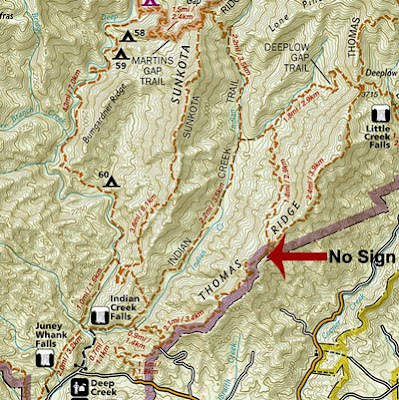

location of missing hiking trail sign in the Deep Creek section of the Great Smoky Mountains national park

Back on the original trail I was hiking on, I went for another 25 minutes mostly downhill now I realized that I must have passed the junction. Trying to check my position on the new 2008 Hiking Trail Map I purchased from the national park service, I could not find myself on the trial given that the new maps have removed all topographical references as well as not showing accurately details such as individual switchbacks.

With water running low (less than a liter now) I realized that I must work on finding my way out of the park and back to my car. My choice would be walk back the way I came or work on find a trail back on a more efficient loop. Without topographical information on my map I had no idea if this shortcut back would be uphill downhill or a combination of both.

I stopped, made an evaluation of where I was, listened and heard way in the distance the sound of rushing water. It can be hard to tell the difference unless very experienced between the sound of water or wind blowing through leaves. Consulting the map which does show large water features I determined I was already on the shortcut I needed to take to get back to the car.

20 minutes later I was at a marked trailhead confirming I was exactly where I needed to be. A few yards away I ran into 2 other hikers who confirmed to me when they were hiking the day before the sign was in fact missing and they also were lost as a result of the missing sign.

As soon as I returned to my car I went to the campground check in and checked the message board - no notes about the missing sign. I then went to the ranger's station and reported the missing sign.

In the winter with limited daylight and using just the new map and a compass I would have been in for a real problem as I could never have taken a chance for a shortcut - I would have had to return the way I came - a far longer trip but the only sure way I know I could have returned.

The new Great Smoky Mountains national park hiking map is terrible and I would suggest only using the National Geographic Topo map of the area. In the winter or when taking a very long hike I always depend on this map and this reaffirms this is the only map I will use out here in the backcountry when hiking in a less familiar area.

Would a GPS have worked yesterday? Maybe. There was a very heavy canopy and I may not have had the ability to get a fix. If it was winter when solo hiking is more dangerous I would have had one with me. In the winter, late fall and early spring the lack of leaves may have helped me get a fix as long as there was not heavy cloud cover and I had a clear shot of the sky.

I don't expect that this sign will be replaced with a day but I do hope that they will put a not on the bulletin board and should put notes at the trail heads around the missing sign that the sign is in fact missing.

Tuesday, January 22, 2008

The Great Smoky Mountains National Park closes many roads due to ice

Today's freezing rain and cold weather caused many road closures in the Great Smoky Mountains National park which will remain closed for at least the rest of the night.

The roads currently closed in the Great Smoky Mountains national park due to ice are:

  • Newfound Gap Road (US 441) from NC to TN
  • Little River Road (73)in TN
  • Wears Cove Road in TN
  • Foothills Parkway East in TN
  • Cherokee Orchard Road in TN
  • Lakeview Drive in NC
  • Old 284 in NC

Saturday, January 19, 2008

Snow falling in NC side of Great Smoky Mountains National Park

Snow is now falling on the NC side of the Great Smoky Mountains and Newfound Gap Road (US 441( and although the road is now clear expect it to close today.

Snow fall is quickly spreading on the Tennessee side and up to 4 inches of accumulation is expected and bitter cold weather predicted for the next few days can keep snow and ice in upper elevations for days.

Friday, November 09, 2007

More construction for I-40 in the Pigeon River Gorge in NC to TN state line

Construction on I-40 will start this spring repaving about 15 miles of the interstate from Fines Creek to the Tennessee - North Carolina border line. Some preliminary work will actually start this month but the major push will have to wait until the warmer weather in the spring of 2008.

Besides repaving the interstate, improved drainage via pavement will be installed and some signs that have seen better days will be replaced. Construction work is expected to close more than 1 lane in each direction and to be completed in June of 2009.

The construction work on I-40 can be a real potential mess for commuters and tourists to the areas as even though roads won't be allowed to close during major holidays, weekends and peak travel times during the 2008 leaf season, since there are virtually no detours drivers can take, the potential for huge bottlenecks and delays are enormous.

Thursday, October 04, 2007

NC Chimney Rock State Park to have land added from Rumbling Bald Mountain

Public access to the Chimney Rock State Park in North Carolina will now be easier thanks to a 1.3 million purchase of 46 acres of land by the Nature Conservancy conservation group whose goal is to sell it the state of North Carolina so it may be added to the new Chimney Rock State Park.

Currently Chimney Rock State Park is comprised of almost 1,000 acres located in Rutherford County which was purchased for $24 million. North Carolina Division of Parks and Recreation spokesman Charles Peek is working with conservation groups in the area in order to purchase as much as 1,500 more acres to what was formerly known as Hickory Nut Gorge State Park.

Currently some areas of the park such as the popular section of the mountain called Cereal Wall which may draw as many as 100 climbers and outdoor enthusiasts on peak weekends is only assessable through private land.

Saturday, March 17, 2007

RV Campers Sales, Service and Parts in NC and TN in Your Smokies Smoky Mountains Directory

Your Smokies camping directory is already one of the most popular on line campsite directory for those who camp with a tent or go RV Camping.

RC Campers Sales, Service and Parts in NC and TN in Your Smokies Smoky Mountains Directory

Now Your Smokies is listing Recreational Vehicles, trailers and mobile homes dealers, authorized repair centers, RV Emergency repair services and stores and dealers that handle parts for your RV or trailer in their huge NC and TN Smoky Mountain Directory with listings in the following popular cities and towns in North Carolina and Tennessee:

NC RV Sales - Repair

TN RV Sales - Repair


Your Smokies is also proud to announce a new sponsor of the Your Smokies site the Good Sam Club (Good Samaritan) where members can enjoy the following benefits:

  • 10% discounts on more than 1,700 campgrounds in the USA and Canada
  • Tips, help and guidance from members only online forums
  • RV trip routing specially designed for RVs so there are no unpleasant surprises with bridge and tunnel restrictions etc.
  • 10% discounts on RV Repairs, parts and accessories at hundreds of dealers.
  • Club activities with more than 2,000 local chapters.
  • FREE Subscription to their special RV magazine: Highways
  • FREE Consumer Advocacy Assistance to resolve RV related service or product problems on your behalf.
  • Special low rates on RV and Auto Insurance, RV financing, and Good Sam RV Emergency Road Service Enrollment.
Join the Good Sam Club!

Happy Motoring!

Monday, March 12, 2007

Bryson City NC Fire: 9 homes and 200 acres destroyed

Bryson City North Carolina: Yet another Smoky Mountains fire is brining in the Grassy Ridge community claiming several mountain ridges in the Pelohi Cove. Dry weather and high winds drove a fire which stared in a valley up ridges devouring everything in its path.

The fires cause is still unknown and under investigation so far has kept more than 100 firefighters busy and prompted a small evacuation Pelohi Cove and several neighboring roads were blocked. Even the Forest Service has been helping contain the blaze by flying in water from Lake Fontana NC.

Not only has Swain County had to deal with wild fires this weekend, brush fires have been reported near the French Broad River, Fairview, and Riceville.

With increased fire danger all throughout the Smokies we ask everyone pay special care with any activity that could spark a wild fire.

Friday, February 23, 2007

National Park Service will start a prescribed burn in Cataloochee North Carolina section of the National Park February 24th 2007

I would suggest if you are visiting the Great Smoky Mountains National Park this weekend that you avoid the Cataloochee NC area because of the smoke, partial road closures, fire fighting equipment and fire personal needed to help restore both pine and Oak woodlands.

Fire can pose a huge danger to the parks inhabitants, historical building, neighboring farms and homes because an uncontrolled fire in the wild can spread like - well - wildfire. Because of this National Parks and state parks and forests have been suppressing forest fires for years.

Unfortunately a natural environment needs fires to maintain a healthy balance and the forests, valleys, fields and woodlands of the Great Smoky Mountains National Park is no exception.

Fires can clear old vegetation, open tree canopies to allow more sunlight to reach the forest floor allowing more bio diversity. Some plants such as some pine trees have seeds that won't germinate unless exposed to heat created by fire. Different species of trees and bushes have different flammability factors and thus a fast burning fire may burn and kill some plants while other plants which are more fire tolerant may not be affected.

Since natural and accidental forest fires have been suppressed for more than 60 years in the Smoky Mountains, some species of tress such as maple trees which have a low fire tolerance, have spread quickly, dominated habitats and have taken over what was traditionally a xeric oak forest community in the Smokies. Along with the black oak, scarlet oak, and chestnut oaks a fire tolerant xeric oak forest community also has hickory trees a staple wood of locally made Smoky Mountains furniture.

The national park service is planning to burn a 530 acre area in the forest of the Cataloochee Valley this weekend in an effort to help in the restoration of both pine and oak woodlands. Oak woodlands are crucial to the survival of black bears in the Smokies as their diet largely consists of acorns and bears commonly use oak trees in order to den. The new habitat and additional forage created by this prescribed burn will also benefit the Elk that have been introduced into the Great Smoky Mountains national park.

Surprisingly this is not the first time that this area has been intentionally burned by the NPS. The same area had a prescribed burn treatment in April of 2004 and more treatments will be needed in order to completely restore the xeric oak forest habitat.

In order to help keep the fire under control that area where the prescribed burn is to take place is bordered an established fire control line, 2 wet drainages, a road, and grassy meadowland all of which borders the open meadows of Cataloochee at the western end of the Cataloochee Valley.

You will also find up to 25 Park firefighters and 2 fire engines will be in the area to keep the fire under control with some fire personnel helping to escort hikers to trails that remain open.

Still insist on going to Cataloochee NC this weekend?

The following areas will be closed:

  • The road from Shanty Branch to the Rough Fork Trailhead in Cataloochee Valley
  • The Hiram Caldwell Cemetery

The following will remain open:

  • Rough Fork Trail
  • Big Fork Ridge Trail
  • Dock Caldwell Cemetery (E of Shanty Branch)

My suggestion is stay away from this section of the GSMNP and let the National Park Service do their job. There is plenty to see and do in other sections of the park.