Showing posts with label Townsend Wye. Show all posts

Thursday, March 18, 2010

2nd Rockslide in Days Closes Portion of Little River Road in Great Smoky Mountains National Park

The Great Smoky Mountains national park has been dealing with numerous rockslides within the park boundaries and 2 large large rockslides along the Spur connecting Gatlinburg with Pigeon Forge Tennessee. Today crews are inspecting another rockslide along the same section of Little River Road between Metcalf Bottoms and the Townsend Wye that was closed last week.

Presently there is no estimated time in which this section of Little River Road will be able to be reopened. Therefore car, motorcycle, van and light pickup truck traffic is being detoured in and out of the park at the Metcalf Bottoms Picnic area through Wears Gap and back in and out of the park for non commercial vehicles of all sizes at the Townsend Wye. Motor homes cannot cross the Metcalf Bottoms Bridge over the Little River and must take an alternate route of Wears Valley Road (321) when traveling between Pigeon Forge and Townsend.

Besides numerous weather related closures the Great Smoky Mountains national park has had to content with all winter, construction in Cades Cove, Clingmans Dome, Balsam Mountain Heintooga, Cherokee Orchard/Roaring Fork Motor Trail and Smokemont is severely limiting access to drivers and visitors of the park.


Saturday, March 13, 2010

Rockslide closes portion of Little River Road in the Great Smoky Mountains national park

Another rockslide in the Great Smoky Mountains National Park along Little River Road forced the park service to close the section of roadway to all traffic between Metcalf Bottoms and the Townsend Wye.

Fortunately, the Sinks area is already closed to all traffic and pedestrian due to construction so no popular areas are directly affected by the closure.

This winter there have been numerous rockslides along the Gatlinburg Pigeon Forge Spur and Little River Road. While some of these rockslides have taken weeks to remove excess debris and complete slope stabilization, initial reports on this slide state that Little River Road will be open to traffic very quickly.

Saturday, August 01, 2009

Cades Cove Loop Road reopens, some other Great Smoky Mountains national park roads still closed

Little River Road in the Great Smoky Mountains national park between the Metcalf Bottoms Picnic area and the Townsend Wye remains closed today as park rangers attempt to find the body of a woman who drowned yesterday by jumping into the flooded Little River and refused to be rescued.

Cades Cove Loop Road which was closed yesterday due to flooding at numerous points is now open t all traffic, bicycles and pedestrians. Flooding and wind damage has kept 2 of the other major roads in Cades Cove closed: Rich Mountain Road and Parson Branch Road. No reopening date is anticipated yet.

In the south end of the Great Smoky Mountains national park in the Balsam Mountain area Heintooga Road is also closed due to storm damage with no reopen date.

Friday, July 31, 2009

Little River Road closed as Great Smoky Mountains national park searches for drowning victim

A section of Little River Road in the Great Smoky Mountains national park will be partially closed Saturday as the park service commences searching for the bodies of a woman who entered Little River and was swept away while refusing to allow a ranger rescue her.

While a park ranger was on patrol along the Little River he observed a white female approximately in her 30's sitting on a rock at the edge of the river. Since her behavior was unusual the ranger decided to check on her at which time she stood up and jumped into the raging river swollen and flooded from earlier today's heavy rains.

The Great Smoky Mountains national park ranger followed her as she was swept down the river and attempted to rescue her by throwing her a life line and float which she picked up and purposely tossed aside.

Little River Road was closed today from the Metcalf Bottoms Picnic area to the Townsend Wye as park rangers and first responders from Gatlinburg's Rescue Squad and Rural Metro Ambulance swarmed the area searching in vain for the women.

Rangers during daylight searched all along the riverbanks of the Little River which was running chocolate brown and loaded with debris. They also set up a vantage point by an area called the Sinks further down river from where the lady entered the water in an attempt to intercept the victim if she floated by.

Today's heavy rains also flooded Cades Cove along Sparks Lane, Hyatt Lane as some other stream crossing prompting the park service to Close Cades Cove Loop Road creating a traffic nightmare at the Townsend Wye.

While working traffic management at the Townsend Wye with 2 other volunteers in the park our park vehicle was struck by a pickup truck transporting kayaks. No injuries were sustained although the back door was taken off the park service's jeep Cherokee used by Volunteers in Cades Cove.

back door was taken off the park service's jeep Cherokee used by Volunteers in Cades Cove

Because Cades Cove Loop Road was closed tonight's very popular 3 mile night hike in Cades Cove with Ranger Mike which crosses a stream on Spark Lane that is to rough to cross today was canceled leading to many disappointed park visitors.

Cades Cove may reopen tomorrow if flood water subside enough.

Despite the extremely flooded conditions of Little River the kayakers pictured below were still out in force even past sunset. Expect the Great Smoky Mountains national park to have many kayakers and extreme tubers enjoy the flooded Little River tomorrow and throughout the weekend.

Despite the extremely flooded conditions of Little River kayakers were still out in force

Tuesday, February 03, 2009

2 more roads close in the Great Smoky Mountains national park

Snow and ice closes 2 more roads in the Great Smoky Mountains national park: Laurel Creek Road from the Townsend Wye to the Cades Cove entrance and the Cataloochee Entrance Road.

Monday, January 19, 2009

More Road Closures in the Great Smoky Mountains National Park

Besides Newfound Gap Road US 441 and Foothills Parkway East being closed, Little River Road from the Sugarlands Visitor Center to the Townsend Wye, Wears Valley to Metcalf bottoms, Roaring Fork / Cherokee Orchard Road, the entrance to Greenbrier, the entrance to Catalooche and old 284 have all be closed by the Great Smoky Mountains national park.

Bottom line: stay of the park except for the edges!

Monday, May 19, 2008

Road closure and construction to last longer then scheduled in the Great Smoky Mountains national park.

The work needed to stabilize Indian Head Cliff on Little River Road in the Tennessee side of the Great Smoky Mountains national park is taking longer than it was scheduled keeping 8 mile section of Little River Road between the Metcalf Picnic area and the Townsend Wye closed for an additional day.

When Little River Road reopens Tuesday evening the 20th it will be reduced to 1 lane while the work will have to continue for at least another week.

Hopefully Little River Road will be open completely by Memorial Day weekend as the Great Smoky Mountains National Park will be busy especially between Gatlinburg and Cades Cove.

Saturday, May 10, 2008

Great Smoky mounatins National Park East - West road Little River Road reopens

Little River Road the main east west road in the Great Smoky Mountains national park reopened today in time for Mothers Day weekend.

Downed branches from last night storm have been cleared off of all of the major roads and all of the trails we have checked show only minimal damage.

As of Monday a section of Little River Road from the Metcalf picnic grounds to the Townsend Wye will be closed completely for the geologic repair to Indian Head Cliff.

Click here for further information about the Little River Road Closure and Indian Head Cliff repair.

Sunday, May 04, 2008

Great Smoky Mountains National park cliff repair causes road closures and detours.

Little River Road on the Tennessee side of the Great Smoky Mountains national park connecting Gatlinburg Tennessee with Elkmont, Metcalf Bottoms, and Townsend Wye will be reduced to shortly to 1 lane and then have a section closed while rehabilitate construction will take place to Indian Head Rock cliff.

This construction and closure will be effecting through drivers attempting to traverse the park to get to Cades Cove and the Tremont sections of the national park whose best option would be to take 321 and avoid the whole mess.

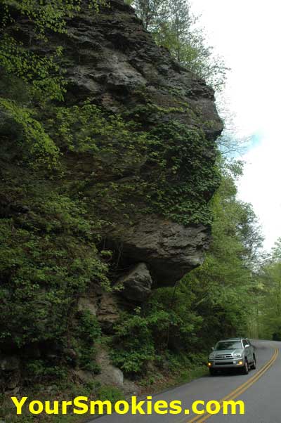
The Indian Head Rock Cliff which is located between Metcalf Bottoms and the Townsend Wye was damaged during the heavy storm in October of 2006 that ripped through the park destroying much in its path.

Along with blowing down hundreds of large trees this storm damaged the Indian Head Rock Cliff rock face triggering a landslide which dumped debris and large boulders onto the Little River Road.

Indian Head Cliff on Little River Road

On April 3, 2008 the Great Smoky Mountains national park awarded a $386,360 contract to Rembco Geotechnical Contractors of Knoxville Tennessee to stabilize the rock face by using polyurethane resin to fill in the large cracks along with using rock dowels based upon recommendations by the Federal Highway Administration geological engineers.

As a result of the rehabilitation of the Indian Head Rock Cliff, drivers will find that the Little River Road lane and complete closures from May 5th to May 19th with a welcome break on Mothers Day weekend May 9-11 when no construction work will be conducted and Little River Road will be fully operational.

Little River Road construction map in the Great Smoky Mountains National Park

The following schedule is subject top change if the weather or if geologic rehabilitation does not go as planned:

  • May 5th through May 8th. Traffic on effected area (see map) will be reduced to 1 lane controlled by flaggers. Drivers can expect delays.

  • May 9th through May 11th. No construction. Both lanes on Little River Road will be open and there will be no delays.

  • May 12th through May 19th. Both lanes of effected area (see map) will be closed to all traffic.

    Eastbound Detour
    Traffic headed eastbound from Cades Cove or Tremont must exit to the Townsend Wye and Detour via 321. Passenger cars and vans may reenter park at Wear Cove Entrance in order to get back onto eastbound Little River Road at Metcalf Bottoms to continue eastward. Larger Vehicles must reenter park Via the Spur.

    West Bound Detour
    Divers of passenger cars and vans coming from Gatlinburg or Elmont wishing to go west to Cades Cove or Tremont section of the Great Smoky Mountains national park must exit Little River Road at Metcalf Bottoms Picnic area and exit park at the Wears Cove entrance and reenter the park at the Townsend Wye. Larger vehicles must exit park at the spur and take 441 and then 321 to the Townsend Wye.

    During May 12th through May 19th Both pedestrians and cyclists will be allowed to go from Metcalf bottoms to the sinks. Little River Road from the Townsend Wye east is closed to all pedestrians and cyclists.

Wednesday, February 27, 2008

Few roads reopen in the Great Smoky Mountains National Park after winter storm

Most major roads such as the Newfound Gap Road - US 441 in the Great Smoky Mountains national park still remain closed due to snow and ice, but a few roads have been opened to traffic.

The Spur connecting Gatlinburg and Pigeon Forge still remains open and now the Gatlinburg bypass is also open to drivers.

On the West end of the national park on the Tennessee side divers can now drive from Townsend to Cades Cove and around the 11 mile loop road as Laurel Creek Road between the Townsend Wye and the Cades Cove loop road as well as the Cades Cove Loop Road have just been reopened.

Tremont Road just west of the Wye off of Laurel Creek Road and the Western Foothills Parkway just outside Townsend has also opened.

As we learn of more roads that open in the Great Smoky Mountains National Park we will post updated reports.