Showing posts with label Tremont. Show all posts

Saturday, October 25, 2014

Fall Color Report for the 4th Weekend in the Smoky Mountains October 2014

If you look outside in mid and lower elevations right now, you would swear it was the first weekend of peak leaf season in the Great Smoky Mountains, not the second. Regardless there areas still see some nice fall colors and for sure there will be more next weekend as well.

The fall leaf colors in the higher elevations of the Blue Ridge Parkway and Newfound Gap Road are gone, however the long range views are still nice. The traffic is extremely heavy though and I would suggest Foothill Parkway West as a better drive.

The Foothills Parkway Spur between Pigeon Forge and Gatlinburg is not showing its best, however there are some decent spots of color along parts of Little River Road and now Laurel Creek Road all the way into Cades Cove.

Cades Cove Loop Road is very crowded and still not at peak in the valley. Rich Mountain Road and Parson Branch Road coming out of Cades Cove both have nice color in spots, and will continue to have color into next week. Both the Gregory Bald Hiking Trails and Hannah Mountain Hiking Trails have decent color and long range views are still very good.

Deep Creek, Tremont and Elkmont are 3 of my top picks right now for a great place to have a moderate hike and see decent fall color in the Great Smoky Mountains national park. All three of these sections of the park have significant water features which add to fall photography even though the amazing fluorescent fall colors along the rivers have yet to show themselves.

Deep Creek North Carolina has some great color along the Loop Trail, Sunkota Ridge and especially the Noland Divide Trail up to and beyond Lonesome Pine to Sassafras, as well as along Thomas Ridge. Other than Little Creek Falls, none of the Waterfalls in the Deep Creek area have color left.

In Elkmont if you hike the Little River, Cucumber Gap, Jake's Creek Loop, there is only limited bright fall colors out as of yesterday. Hiking further up Jake Creek Trail especially up the Panther Creek Trail there are spots of colors which are wonderful. A hike along Meigs Mountain trail or the Curry Mountain Trail will not be disappointing.

I normally love to walk the roadway in Tremont this week in October and stop all along the way at the many pools and small waterfalls and take photos of the fall colors in the leaves in the trees above reflecting in the water. This is not one of the best years for that, at least not yet.

Hiking along the West Prong Trails is very nice right now, but I suggest in the next few days to still take advantage of the Middle Prong Trail and the Greenbier Ridge Trail, however there is no color left by the time you get up to the AT. Indian Flats Falls is nice as the water flow rate is fairly low, but it is not a waterfall for "fall pictures".

Reports have come in the color is getting much nice along the Lakeshore area, but I have not been there since Monday and sadly many areas that should provide brilliant color have not done so this year even though based upon high hope we had at the start of the season.

Monday, May 06, 2013

Where and When to see Synchronous Fireflies in the Smokies in 2013

Why do more than a thousand people a night walk around in the dark without lights in the Great Smoky Mountains National Park every June? For a very good reason...to see the worlds famous Smokies Synchronous Fireflies.

To see such a miracle of nature is simply amazing with the blinking of tens of thousands of lightning bugs that start randomly, then start flashing all at once or in patterns together, and then as fast is it starts, blackness envelops the area and the sounds of the night forest seems to skip a beat, and then, it all starts again.

The flashing of the fireflies which are actually beetles, vary in color, seasonal timing, duration and pattern from species to species, but the main purpose for all of them to flash or glow is to attract a mate.

The majority of the display that we see from the Synchronous Firefly Photinus carolinus which can be found in the Great Smoky Mountains National Park and other wooded areas and fields close by is the males answer to the female's initial signal of light, which draws him ever closer to her.

While finding the place where the Synchronous Fireflies will flash is not that hard if you can go back to the same spot over and over again from May until July, it's highly impractical.

Virtually every spot the biologists have looked for the Synchronous Firefly in the Great Smoky Mountains National Park, they have found them, as long as the biologist timing was right.

Timing is everything when it comes to the fireflies as you only have about a 2 week window when they flash their best, before which they are underground and after which they have mated, laid their eggs and have died.

What you have to do to find the is Synchronous Lightning Bugs is understand when they are going to emerge from the soil as fully grown adults ready to mate. In lower elevations of the National Park at the 2,000 foot mark such as in Elkmont where some of the best firefly displays can be seen, that can be as early as the Early May to Mid June.

On average, low elevation peak synchronous firefly activity is the first into the second week of June; however, in 2012 it was the last week of May due to unseasonably warm weather. This year's seasonal emergence of plants and insects was about 3 weeks later than last year so we are right on target with the parks estimation at his point.

One of the best ways to see the fireflies is to take the shuttle buses running from June 6th through June 13th that takes you from the Sugarlands Visitor Center parking area to the Little River Hiking Trail parking area in Elkmont.

Sadly, far more people want to go see the fireflies in the Smokies than the national park can accommodate, so for years the first come first served system of the firefly shuttle buses have been scrapped for a reservation system that leaves just as many people missing out on the show, but not waiting in long lines for no reason. Advance parking passes to buy tickets sold out in hours with the remaining half going to sell out fast on the day before each departure.

Another choice area for see in the Synchronous Lightning Bugs is the Great Smoky Mountains National park is in Tremont for the 3rd and last week in May as the elevation is about 800 or so feet less than in Elkmont and they do emerge and mature sooner. This road also sees very little traffic so the lights won't disturb the fireflies as much.

If you feel like walking, another great spot to the see the fireflies is to hike into Cades Cove which is allowed even as the road is closed to motor vehicle traffic. Here in Cades Cove, which is at an elevation between Tremont and Elkmont, choice areas are Hyatt Lane, by the Abrams Falls Trailhead or by Sparks Lane.

Not planning or arriving to the Smokies until the 2nd weekend in June or later and still want to see the synchronized fireflies in the GSMNP? Higher up is when you need to go. Try the Newfound Gap Parking Area, around Clingmans Dome, along the Foothills Parkway East or Foothills Parkway West.

Related Smokies Fireflies News Stories

Synchronized Fireflies in the Great Smoky Mountains

Friday, March 16, 2012

Road Closures in the Great Smoky Mountains National Park

Two needed road closure in the Great Smoky Mountains National Park planned to start next week may mean hikers will need to alter their plans and a shortcut to 321/Wears Valley Road will be inaccessible for more than 2 weeks.

Wears Gap Road Entrance to the Metcalf bottoms will be closed March 19th until April 5th due to work on bridge and the power line cutting off access to the Little Greenbrier School, as well as the Roundtop hiking trail and Little Brier Gap Trailhead.

During all day March 20th and 27th Tremont Road in the Great Smoky Mountains National Park will be closed for the delivery and installation of a new septic tank cutting off all access to the Great Smoky Mountains Institute at Tremont as well as the trailheads for West Prong Hiking Trail, Lumber Ridge Trail, and the Middle Prong Trailhead.

Outside of the park, there was another rockslide on 129 also called the Tail of the Dragon blocking all traffic near the Tennessee and North Carolina border. Department of transportation officials expect the road to be open some time late next week

Road Closure Information in the Great Smoky Mountains National Park

Thursday, January 22, 2009

A few roads in the Great Smoky Mountains Nat Park

A few roads just opened in the Great Smoky Mountains National Park but a still considered treacherous.

The newly opened roads are:

  • Little River Road from the Sugarlands to the Townsend Wye.
  • Laurel Creek Road to Tremont and Cades Cove
  • The Spur from Gatlinburg to Pigeon Forge
  • Cades Cove Loop Road
  • The Gatlinburg Bypass section of the Spur
  • Entrance Road to Cosby
  • STAY ALERT AND DRIVE SLOW!

    Friday, June 13, 2008

    2 more days left on Great Smoky Mountains national park Rainbow Trout fish out.

    Today and tomorrow are the last 2 days you can catch and keep as many Rainbow Trout no matter the size in the Tremont section of the Great Smoky Mountains national park.

    In order for the national park service along with the help of funding by Friends of the Smokies to restore the native Brook Trout species back into the Tremont Tennessee section of the Great Smoky Mountains national park, the Rainbow Trout must be removed. What Rainbow Trout that don't get removed will be poisoned in September.

    The first day of the fish out anglers brought home more than 110 fish. As of last count mid afternoon yesterday, less than 460 fish in total have been caught during the whole fish out. This number could have been considerably higher if more fisherman showed up to take advantage of the fish out rather than fishing in other sections of the Great Smoky Mountains national park.

    Here are the complete details for the Great Smoky Mountains national park Rainbow Trout removal in Tremont.

    Tuesday, June 03, 2008

    No limits on Rainbow Trout in Tremont section of the Great Smoky Mountains National Park

    Even though Rainbow Trout size and quantity limits are lifted on an 8 mile section of the Tremont area of the Great Smoky Mountains national park, less than 10 anglers are taking advantage of this special opportunity to help the national park and fish in one of the most beautiful areas to fish in Tennessee.

    Yesterday the park recorded that 115 Rainbow Trout were caught as well as one legal sized Brook Trout in the special fishing zone that was set up where the native Brook Trout restoration will take place this September.

    No limits on Rainbow Trout in Tremont section of Great Smoky Mountains National Park

    Park service employees are expecting a much larger crowd this weekend so the best time to come out and enjoy the peace and quiet as well as bring home a good dinner will be during the week. There should be plenty of fish to catch as well as space for fisherman this weekend as well.

    In order to take advantage of this limit free Rainbow Trout harvest to help with the Brook Trout restoration program you must register on the temporary fishing registration tent a few hundred feet from the Middle Prong Trailhead in Tremont.


    Great Smoky Mountains national park fish check in

    Only the Rainbow Trout in the designated area have size and quantity limits lifted. Brook Trout must be of legal size to be kept and only artificial lures with a single hook are allowed to be used to catch any fish in the GSMNP.

    The reason why size and catch limits still apply to Brook Trout in the area is that prior to the national park service biologist to administer the poison to the water which will kill the remaining Rainbow Trout in September, biologists will use electro-fishing to stun and then remove any Brook Trout that they can so that these native fish can be safely held until the water is ready for their reintroduction. This is also the reason why single hooks only can be used when fishing in the area to reduce hooking mortality to the Brook Trout.

    To fish anywhere in the Great Smoky Mountains National Park you must have a valid Tennessee or North Carolina fishing license if you are are 13 years old or older. You can read about this and other national park fishing regulations on Your Smokies.

    Sunday, May 04, 2008

    Great Smoky Mountains National park cliff repair causes road closures and detours.

    Little River Road on the Tennessee side of the Great Smoky Mountains national park connecting Gatlinburg Tennessee with Elkmont, Metcalf Bottoms, and Townsend Wye will be reduced to shortly to 1 lane and then have a section closed while rehabilitate construction will take place to Indian Head Rock cliff.

    This construction and closure will be effecting through drivers attempting to traverse the park to get to Cades Cove and the Tremont sections of the national park whose best option would be to take 321 and avoid the whole mess.

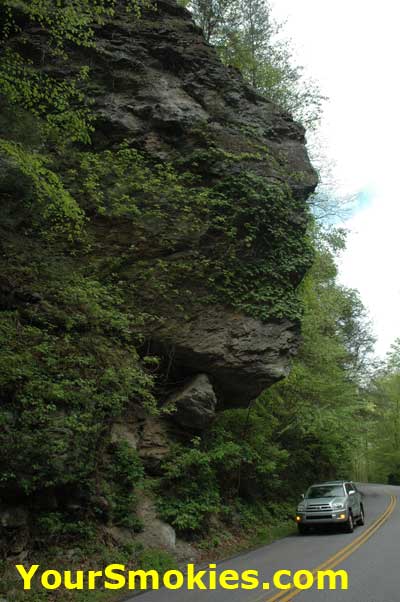
    The Indian Head Rock Cliff which is located between Metcalf Bottoms and the Townsend Wye was damaged during the heavy storm in October of 2006 that ripped through the park destroying much in its path.

    Along with blowing down hundreds of large trees this storm damaged the Indian Head Rock Cliff rock face triggering a landslide which dumped debris and large boulders onto the Little River Road.

    Indian Head Cliff on Little River Road

    On April 3, 2008 the Great Smoky Mountains national park awarded a $386,360 contract to Rembco Geotechnical Contractors of Knoxville Tennessee to stabilize the rock face by using polyurethane resin to fill in the large cracks along with using rock dowels based upon recommendations by the Federal Highway Administration geological engineers.

    As a result of the rehabilitation of the Indian Head Rock Cliff, drivers will find that the Little River Road lane and complete closures from May 5th to May 19th with a welcome break on Mothers Day weekend May 9-11 when no construction work will be conducted and Little River Road will be fully operational.

    Little River Road construction map in the Great Smoky Mountains National Park

    The following schedule is subject top change if the weather or if geologic rehabilitation does not go as planned:

    • May 5th through May 8th. Traffic on effected area (see map) will be reduced to 1 lane controlled by flaggers. Drivers can expect delays.

    • May 9th through May 11th. No construction. Both lanes on Little River Road will be open and there will be no delays.

    • May 12th through May 19th. Both lanes of effected area (see map) will be closed to all traffic.

      Eastbound Detour
      Traffic headed eastbound from Cades Cove or Tremont must exit to the Townsend Wye and Detour via 321. Passenger cars and vans may reenter park at Wear Cove Entrance in order to get back onto eastbound Little River Road at Metcalf Bottoms to continue eastward. Larger Vehicles must reenter park Via the Spur.

      West Bound Detour
      Divers of passenger cars and vans coming from Gatlinburg or Elmont wishing to go west to Cades Cove or Tremont section of the Great Smoky Mountains national park must exit Little River Road at Metcalf Bottoms Picnic area and exit park at the Wears Cove entrance and reenter the park at the Townsend Wye. Larger vehicles must exit park at the spur and take 441 and then 321 to the Townsend Wye.

      During May 12th through May 19th Both pedestrians and cyclists will be allowed to go from Metcalf bottoms to the sinks. Little River Road from the Townsend Wye east is closed to all pedestrians and cyclists.

    Thursday, November 15, 2007

    2007 Smoky Mountains leaf color change season peak

    Leaf color changes thought the Smokies have just passed their peak but there will be plenty of color in the leaves of the trees and the mountainsides for weeks to come in Tennessee as well as in North Carolina.

    In the Tennessee Smoky Mountains there are still plenty of trees still in the green phase but most have turned into light green, yellows, oranges and flaming reds giving a nice contrast to the tans and browns of leaves that changed colors sooner.

    Last weeks cooler temperatures helped move things along in Tennessee’s leaf season and driving down Newfound Gap Road (441) from the North Carolina side by the 7 mile marker the riot of color in the leaves really show off. Of course now day by day this will work its way down to the lower elevations.

    I have still found tons of great color in all of the hikes I have done in Cades Cove, Elkmont, Tremont, Greenbrier, Sugarlands and even Crosby this week and see that the oaks and the maples have at least another 2 weeks more color left in them.

    Just as in real estate the key word is location. Some of the road sides are now past peak but once you wander in to the valleys or look up the side of the mountains you can see the yellows, green, reds and browns that make the Smokies a great place to see autumn colors.

    While the peak has passed sooner in North Carolina there are still tremendous pockets of fall colors with hardwood trees now showing their flashy colors. Trees in some of the higher elevations have lost most of their leaves and the last few days’ rain has knocked off any of the leaves that were about to fall.

    Hiking along ridge lines yesterday in North Carolina as well as driving along the Blueridge parkway I still found eye-popping colors and spectacular views everywhere.

    Today may see some snow flurries in the upper elevations with little or no accumulations making for some spectacular pictures. No more snow is predicted for the next week.

    If you are planning on coming to the Smokies in the next week or 2 you won’t miss out on the spectacular fall colors – just most of the traffic!