Showing posts with label Hiking Trail. Show all posts

Friday, March 16, 2012

Road Closures in the Great Smoky Mountains National Park

Two needed road closure in the Great Smoky Mountains National Park planned to start next week may mean hikers will need to alter their plans and a shortcut to 321/Wears Valley Road will be inaccessible for more than 2 weeks.

Wears Gap Road Entrance to the Metcalf bottoms will be closed March 19th until April 5th due to work on bridge and the power line cutting off access to the Little Greenbrier School, as well as the Roundtop hiking trail and Little Brier Gap Trailhead.

During all day March 20th and 27th Tremont Road in the Great Smoky Mountains National Park will be closed for the delivery and installation of a new septic tank cutting off all access to the Great Smoky Mountains Institute at Tremont as well as the trailheads for West Prong Hiking Trail, Lumber Ridge Trail, and the Middle Prong Trailhead.

Outside of the park, there was another rockslide on 129 also called the Tail of the Dragon blocking all traffic near the Tennessee and North Carolina border. Department of transportation officials expect the road to be open some time late next week

Road Closure Information in the Great Smoky Mountains National Park

Monday, May 17, 2010

Black Bear Attacks Great Smoky Mountains National Park Visitor on Popular Hiking Trail as Horrified Crowd Watches Helpless in Disbelief.

Last Wednesday as Mr. and Mrs. McQueen were hiking along the Laurel Falls Hiking Trail in the Great Smoky Mountains national park admiring the wildflowers, lush forest growth and pretty views along the way to the Laurel Falls Waterfall, a large female black bear which had been food conditioned and lost its natural fear of humans, jumped out of bushes along the trail and proceeded to gnaw off appendages from the couple as a group of horrified people looked on.

Black Bear Attacks Great Smoky Mountains National Park Visitor on Popular Hiking Trail as Horrified Crowd Watches.

Blood, shredded shoes, clothing, and other remnants of the carnage lay scattered along the trail a gruesome reminder to all of the danger and power that a black bear welds with its bone crushing jaws, large teeth and razor sharp claws.

Great Smoky Mountains national park wildlife biologists going on the description of the dangerous human conditioned black bear trapped all the bear they could in the area that the attack on the hiker occurred.

Since they only had a general description, they systemically slaughtered every black bear they could find including the orphaned black bear cubs that are only a few months old and could not fend for themselves.

This story is loosely based upon a true event that just happened in the Great Smoky Mountains national park. Well make that very loosely. Well make that a compete exaggeration to make a very valid point.

A 26 year old hiker from Wilton, Connecticut named Sean Konover did in fact sustain minor injuries last week when in an effort to get a picture of a small 60 pound female black bear, he and dozens of other visitors around him insisted in disregarding common sense by allowing a bear to approach them too closely. Close enough in fact to bite the hiker, Sean Konovers foot, leaving a small puncture would that did not require any medical attention.

This dangerous black bear encounter occurred along the extremely popular Laurel Falls hiking trail, which traditionally not only has a tremendous amount of hikers but black bear as well, many which are food conditioned each year.

Black bear along with other wildlife get food conditioned when people intentionally or inadvertently allow wildlife to consume food or garbage. People sometimes throw food at wildlife to coax it to come closer than it normally would just to see it up close and or photograph it.
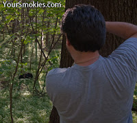
dangerous black bear encounter occurred along the extremely popular Laurel Falls hiking trail

Unfortunately, a good conditioned animal is trained that humans and human scent means food and it will lose some or all of its fear of humans making it more likely to beg for more food, steal food or attack someone for food. It may attack to protect territory where it would have normally run away before food conditioning.

Food conditioned animals generally lose half their life expectancy as their health can be adversely effected by human food and garbage, they are more susceptible to getting hit by cars, or have to be killed because they no longer are acting wild and they damaged property or threatened the safety of humans. What a tragic waste.

Though you may only be giving human food to an animal, you are teaching it to eat or at least examine anything that has a human scent.

Food conditioned animals may also eat non-food items such as foil potato chip bags because it smells like food and taste salty. Can you imagine what you would feel like if you ate a foil potato chip bag?

Animals cannot discriminate as to what garbage is because what smells like food in a natural environment is in fact food. Only humans produce garbage.

Peanut shells, apple cores and orange peels though biodegradable are enticements that make good wildlife go bad. Throw it on the ground and if you are caught, expect to get a nice ticket from a not so happy park ranger.

food enticements make good wildlife go bad

After the minor black bear attack the GSMNP officials initially learned of the incident from other visitors that were also on the Laurel Falls trail, but later, the injured man Sean Konover also reported his injury.

Intentionally approaching a bear or elk closer than 50 yards (150 feet) or close enough that it changes the animals behavior, is a violation of park regulation meant to protect humans as well as the parks wildlife. No citations were issued by the park service at this incident.

As for the young 60-pound black bear, she is not so lucky. A bullet to head is her fate. Why? Because some people wanted to take a picture of a black bear up close after others who came to visit the Great Smoky Mountains national park were slobs and left garbage along a hiking trail or may have thrown food at wildlife in violation of park rules and a ticketable offense.

Fortunately, she was not a mother bear with young cubs where as her death sentence would mean a death sentence for her offspring. She had identifiable features so fortunately a large number of bear did not have to be captured and killed to be sure to get the offending black bear that attacked the hiker was stopped form hurting anyone else. Also fortunate was the fact that she was able to be caught within 24 hours and no one else was injured.

As expected this has been a very active year for black bear in the Great Smoky Mountains national park already mainly due to the lighter than normal mast crop in mid elevations of the park so that the fall feeding frenzy did not fatten up the black bear as much as a good year would. As a result, this spring they emerged a little more hungry and desperate for food than most years.

This year has also been tough on young black bear cubs in the park some of which had to be rescued and brought to the Appalachian Bear Rescue center who desperately needs more food to feed and funding and supplies to help house all of the rescued black bears that have been brought to them.

With more than 9 million visitors a year coming to the Great Smoky Mountains national park, which has a black bear population of more than 2 per square mile, it's not a question of if there will be another fatal or serious black bear attack will occur but when. If all of us who are on the park behave appropriately and do not feed animal or approach them too closely, maybe the next attack will not be in our lifetime.

Intentionally approaching a bear or elk closer than 50 yards (150 feet) or close enough that it changes the animals behavior, is a violation of park regulation

Not feeding wildlife intentionally or approaching them too close are important first steps. Securing garbage in sealed bear proof garbage pails is also important as well as not leaving coolers with food or the smell of food or even garbage in the back of a pickup truck. If you are camping in the backcountry all food, garbage, toiletries and smelly clothes have to be hung on the bear proof wires and elevated where bear cannot reach it.

Finally, I have seen many crazy and foolish things in the Great Smoky Mountains National park, but this one amazes me every time I think about it. Last May a black bear was causing serious issues on the Abrams Falls Hiking trail in Cades Cove, so much so, a warning was posted at the trailhead and the bear was so dangerous that the Abrams Falls Hiking trail was closed due to aggressive black bear activity the next day.

dog that was tied up attached to a car parked as close as possible to where there was a black bear warning sign.

Pictured above is a dog that was tied up attached to a car parked as close as possible to where there was a black bear warning sign. Left out in case the dog got thirsty was a dirty spaghetti can filled with water that had a slick of oil and tomato sauce on the top.

She left her dog this way for more than 3 hours as she hiked. This is enticing a bear with both food and a pet which is tied up that certainly can't run away or fend for itself.

Please act responsibly around wildlife and the life you may save could be your own.

Related Smokies News Stories:

Recent Bear attacks in Great Smoky Mountains National Park

Saturday, June 20, 2009

Aggressive black bear closes popular Cades Cove Hiking Trail in the Great Smoky Mountains

The Great Smoky Mountains national park has had a black bear problem for weeks in the back end of Cades Cove at the Abrams Falls Hiking Trail and has finally been forced to close the trail for visitor and the bear's safety.

The closure of the Abrams Falls Hiking Trail starts on the dirt road before the parking lot area so the Rabbit Creek hiking trail in Cades Cove is also affected.

Aggressive black bear closes popular Cades Cove Hiking Trail in the Great Smoky Mountains

There are other hiking trails with black bear problems in the Great Smoky Mountains national park which have warnings issued on them include: the Little River hiking trail, The lower portion of Trillium Gap trail near Grotto falls and the lower portion of Crooked Arm Ridge trail.

Great Smoky Mountains national park Black Bear Information

Sunday, May 24, 2009

20 year old hiker Drowns in the Great Smoky Mountains national park

The normally quiet Sunday evening in the Great Smoky Mountains national park was shattered with the sound of sirens from park rangers racing to the Abrams Falls Hiking trail in the back end of Cades Cove. The last vehicle racing to the scene was a park ranger's pick-up truck with a gurney and a ladder in the bed.

Few details have been released other than a 20 year old male has drowned presumable just under the Abrams Falls which is swollen with today's rain. Because of the darkness and the dangerous conditions, the body will have to wait to be retrieved by divers tomorrow at which time the name and hometown of the drowning victims will be released.

20 year old hiker Drowns in the Great Smoky Mountains national park

Earlier today it was reported that 2 young women were jumping off the falls into the pool underneath. Abrams Falls is the highest volume waterfall in the Great Smoky Mountains national park and the pool beneath has swift currents, rocks, branches and logs that entangle swimmers in its 25 foot depth.

The Abrams Falls hiking trail has seen numerous serious falling accidents as well as downing deaths and has been ranked as one of the top 10 most dangerous hiking trails in all national parks.

Saturday, May 02, 2009

Laurel Falls Hiking Trail Fire Damage Report

Wild fires in the Great Smoky Mountains national park are inevitable and in fact in some cases even encouraged under controlled circumstances. This is not the case with this week's Laurel Falls Wildfire which threatened one of the parks most valuable natural resources as well as homes and businesses close by.

 Laurel Falls wild fire was set accidentally by an illegal campfire

The Laurel Falls wild fire was set accidentally by an illegal campfire similar to the one pictures here I found 2 days ago in the Greenbrier section of the park. There was a wildfire warning the day this fire was made and since the weather conditions were right and there was plenty of fuel to feed a brush fire with all of the hardwood litter on the forest floor and beetle damaged trees, the fire quickly got out of hand.

Dozens and dozens of firefighters worked with hand tools making scratch lines and fire breaks to slow the spread of the wild fire, along with setting small controllable fires to burn up any fuel they could before the main fire reached the area.

a light helicopter dropped loads of water taken from a pond in Wears Valley

Along with almost 90 men on the ground fighting the fire, a light helicopter dropped loads of water taken from a pond in Wears Valley on the area, while a 2 engine reconnaissance plane used a spotter to help control the ground crew and lead in the water taker plane as it would drop its load of water and flame retardant flown in all the way from Chattanooga.

The hiking trail to Laurel Falls is a short paved trail less than 1-1/4 miles long which takes you to one of the most attractive waterfalls in the Great Smoky Mountains national park. This section of the trail has a limited incline gaining about 600 feet to the falls and year round has some overlooks affording visitors a view of mountains within the GSMNP.

The Laurel Falls waterfall is quite impressive and is where most of the visitors who come to the most poplar hiking trail in the Great Smoky Mountains national park stop. In fact the Laurel Falls Hiking trail continues far past where it is paved and continues another 1-1/2 miles gaining another 950 feet in elevation before it reaches the next trailhead where you can take a short 1-1/2 round trip hike up to the peak of Cove Mountain.

The stretch of the Laurel Falls Hiking Trail past the falls contains largest concentration and some of the best old growth trees that can be accessed in the Great Smoky Mountains national park. These huge old growth trees were never logged as they were not accessible to the Little River Logging Company who clear cut large areas of this wilderness before it became a national park.

The first quarter of the way up the waterfall trail, other than the smell of an old campfire in the air you would never know that a huge battle against a wild fire was just fought on this trail. Why look to the left and you will see one the first flaming azaleas still blooming in the park.

one the first flaming azaleas blooming in the park

The last 2/3rd of the trail are another story. Clear fire damage is visible on both sides of the Laurel Falls Hiking Trail. Huge charged logs lay on the ground many of which are cut into more manageable sizes with the use of a chain saw.

There is now an obvious absence of normal understory plants and small bushes in most areas and blacked pine cones and scorched empty soda cans previously hidden on the first floor can now be seen scattered about on the forest floor or mountainside on the rest of the way the waterfalls.

Clear fire damage is visible on both sides of the Laurel Falls Hiking Trail

Though it looks terrible now, this damage along the hiking trail is very minimal as most of the mid and upper level canopy has remained untouched and bright green in huge contrast the to the black scorched forest floor.

By the end of the summer, other than the scorched logs and tree trunks, most of the understory will have grown back and the rhododendrons and other bushes should be fine by next spring.

Luckily even though almost 270 acres of this beautiful forest between Elkmont and the Sugarlands was damaged by the wildfire, the area past the Laurel Falls remains untouched.

Once you pass the falls and hike up the double switchback to the other side of Chinquapin Mountains on the back end of the trail, larger trees become more and more numerous and the wildflowers more abundant. A few hundred yards more and you start to see the parks old growth giants scattered about.

This forest has always felt more primordial to me with its huge trees, dark green ferns and heavy low cover of wildflowers and is one of the most tranquil areas of the entire Great Smoky Mountains national park. I have hiked all of the trails in the park and time and time again I find myself taken aback by the beauty of this trail.

huge trees, dark green ferns and heavy low cover of wildflowers

Within a few minutes along this section of the trail you forget you just went such major destruction. Back on this section of the trail you smell the fresh green of spring and the smell of old stale smoke is no longer discernible.

Back on this section of the trail you smell the fresh green of spring

Today you can see plenty of wildflowers which have already peaked in other sections of the park including: Large Flowered Trillium, White Erect Trillium, Painted Trillium (pictured below), White Violets, Hepatica, Rue Anemone, Silverbell, Wild Strawberry, Star Grass, Smooth Yellow Violet, Common Blue Violet and Squaw root coming up through the leaves everywhere.

Today you can see plenty of wildflowers which have already peaked in other sections of the park such as this painted Trillium

Thanks to the valiant efforts of our firefighter, one of the most precious resources on the Great Smoky Mountains has been saved form destruction. The economic cost to fight the Laurel Falls Wild Fire will be staggering.

Friday, May 01, 2009

Laurel Falls and Stony Ridge wildfires in the Great Smoky Mountsins national park update

Time and rain have been huge helps in the battling the 2 wildfires burning in the Great Smoky Mountains national park.

Presently the Laurel Falls fire which is East of Elkmont and West of the Sugarlands TN is still burning but is more than 75% contained.

As long as conditions keep improving as they have the past 2 hours we may see the following closed hiking trails reopen as soon as late this afternoon:

  • Cove Mountain Hiking Trail
  • Laurel Falls Hiking Trail
  • Little Brier Gap
  • Little Roundtop Hiking Trail
  • Little Greenbrier Hiking Trail
  • Metcalf Bottoms Hiking Trail

At this point 267 acres have been burned by the Laurel Falls wild fire and no structural damage or specimen old growth trees have been damaged.

Laurel Falls fire which is East of Elkmont and West of the Sugarlands TN

The Stony Ridge Wildfire has already consumed 1,557 acres and is now 60% contained.

The only pubic access areas closed is a section of the Bluer Ridge parkway from Soco Road - US 19 to Newfound Gap Road - US 441 just a short distance north of the entrance to the Great Smoky Mountains national park in Cherokee North Carolina.

Stony Ridge Wildfire has already consumed 1,557 acres

Thursday, April 30, 2009

Laurel Falls TN and Stony Ridge NC Wild Fires still burning in the Great Smoky Mountains national park

The national park service released management of the 2 wildfires still burning in the Great Smoky Mountains National Park to an Interagency Incident Management Team. This team specializes in directing and providing logistical support to large incidents, especially fires.

Currently the Laurel Falls fire which was started by an illegal campfire has affected more than 250 acres and has shut down the extremely popular Laurel Falls hiking trail is only 25% contained despite days of intense firefighting efforts by almost 90 firefighters with air support. At this time the rare old growth forest behind Laurel Falls are not in danger.

Laurel Falls fire which was started by an illegal campfire has affected more than 250 acres

Plenty of fuel for this wildfire was and still is available as a prescribed burn has not been done in this area for a very long time. This section of the park really did need the natural cleaning of fire to help increase the biodiversity. Firefighters are burning areas in front of the wildfire right now to reduce its fuel.

Expect the Laurel Falls hiking trail to be closed for some time even after the fire is out to be sure there are no hot spots are hanging trees that could fall onto visitors.

Since fire personnel are tied up fighting this fire it will take days for the Roundtop Trail to be reopened because crews need to examine the trail and surrounding area before it can be deemed safe.

More than 150 firefighters are working on the Stony Ridge Wildfire with the use of air support

The Stony Ridge Wildfire in the Great Smoky Mountains national park was started by a downed power line and has already scorched at least 1,200 acres in the Cherokee North Carolina area and has shut down the northern most section of the Blue Ridge Parkway between US 19 - Soco Road and US 441 Newfound Gap Road in the Great Smoky Mountains national park. US 441 Newfound Gap Road is not impacted at all other than occasional smoke.

More than 150 firefighters are working on the Stony Ridge Wildfire with the use of air support and at this time it is halfway contained. The western perimeter at this time is secured and crews are battling to secure the eastern perimeter by the Blue Ridge Parkway.

The cool damp weather from last night and now today has been some help and we can only hope that we get more rain though the forecasts are saying there is only a 30% chance of rain today.

Tuesday, April 28, 2009

Wildfire closes Laurel Falls and Little Roundtop Trails in Great Smoky Mountains national park.

Last nights wildfire east of Elkmont in the Tennessee section of the Great Smoky Mountains national park lit up the night sky and forced the closure of the Laurel Falls Hiking Trail and parking area and the Little Roundtop hiking trail.

A combination of a few days without rain, unseasonably warm weather, very low humidity and winds gusting from 10 - 15 mph was the perfect storm for a wildfire.

Another wildfire burned at least burned at least 30 acres and some structures forcing evacuations in the Cobbly Nob area between Cosby and the Gatlinburg / Pittman Center area. Witnesses miles away still see and smell smoke from this fire.

Based upon today's weather forecast, the danger of wildfires is still high.

Tuesday, April 07, 2009

Wildflowers blooming throughout the Great Smoky Mountains national park right now

Though the last 24 hours may feel more like winter than spring, the wild flowers throughout the Great Smoky Mountains national park have been blooming for weeks.

While I feel as though the best time to catch the wildflowers is from April to May, the Great Smoky Mountains are blessed with such biodiversity and micro climates that you can find plants blooming until mid October.

picture of Dutchmen's Breeches taken by the Chimneys in the Great Smoky Mountains national park

What's great about the park being so large and having more than a 4,000 foot elevation range between its highest an lowest point is that you can chase a blooming season starting at lower elevations and warmer southern exposures to the higher elevations and more northern exposures to prolong the duration of peak bloom.

I have made a list below of plants observed in bloom while I was hiking inside the GSM national park.

A trillium leaves and bloom in the GSMNP

The first wildflowers I observed blooming in the Great Smoky Mountains national park were Toothwort, Large Flowering Trillium, Yellow Trillium and Blood Root.

Also deep into the bloom cycle right now are Squirrel Corn, Sweet White Violets, Spring Beauty, Trout Lily, Dutchmen's Breeches, Halbred Leaf Violet, Common Blue Violet, Smooth Yellow Violet, Trillium Erect, White Fringed Phacelia, Rue Anemone, Fraser's Sedge and Wild Ginger.

Just starting to show right now are Wild Phlox, Wild Geranium, Hepatica, Wood Anemone, Prostrate Bluets, Bishop Caps and Birdfoot Violet.

While some of the wild flowers in the GSMNP are big, bright and showy, others can only really be appreciated with a magnifying glass. An example of one of the tiny flowers is pictured right below. The individual flowers in this grouping are so small see how large the tip of a house key looks near them.

tiny wildflowers blooming in the Great Smoky Mountains National Park

My favorite wildflower hiking trails (not in specific order) are Old Settlers Trail, Porter Creek, Big Creek, Finley Cane, Lower Mount Cammerer, Cucumber Gap, Thomas Divide, Rattlesnake, the lower part of Low Gap, Camel Gap and Baxter Creek, Goshen Prong, Flat Creek, Wet Bottoms, Ace Gap, Beard Cane and Mingus Creek. (Complete list of hiking trails in the Great Smoky Mountains national park and what sections they are in)

Beside these highlights I listed, every single hiking trail in the Great Smoky Mountains national park has its own treasure of wildflowers you can see.

Don't want to go hiking to see wildflowers? You can see countless wildflowers right along the roadside or on any of the quiet walks along Newfound Gap Road, Laurel Creek Road and Little River Road.

I am sure that I have missed many great wildflowers found inside the park blooming right now and have not had a chance to identify many of the plants I have seen as well so please feel free to comment to this post so I can add in your observations. I ask that you do not identify specific locations of endangered, rare or plants highly prized by poachers such as Yellow Ladyslipper or Ginseng.

Please observe the federal laws protecting all plants and wildlife in the Great Smoky Mountains national park by taking only pictures and when doing so be careful not to crush or disturb nearby plants.

Wildflower season in the Great Smoky Mountains national park is breathtaking and magical. Please leave the magic for others to enjoy.

Sunday, May 25, 2008

Tragic death of 2 year old on hiking trail in Chimney Rock Park

Hiking with his family in the North Carolina Chimney Rock Park, a 2 year old from Spartanburg South Carolina fell yesterday morning to his death in an area which has a steep drop off.

While park staff did what they could including repelling down a cliff, administering CPR and extracting the youth and transporting the child to a hospital their effort were in vain as the child tragically died.

The trail was closed off during rescue efforts which took under 2 hours included the help of Emergency response crews, fire and police who all arrived at the scene of this accident in Chimney Rock Park.

According to Rutherford County Chimney Rock Park Superintendent Adrienne Wallace the accident is under investigation and it is unknown how far the child fell as well as how the child was able fall given the fencing that lines the hiking trail.

Sadly what should have been a glorious day the park ended in an earth shattering event for the family. Many hiking trails and especially waterfalls have had serous injuries and deaths when people have climbed on wet rocks, left the designated trail or left small children unattended or not under direct control by holding their hand.

Most hiking trails do not have fencing or railings to protect people from falls and this accident shows that even fencing or rails does not mean a deadly accident can still not occur.

As a professional hiker who hikes between 10 – 15 miles a day year round I can tell you I personally slipped 3 times in the past week. I was able to catch myself twice with my hiking poles and maintain my balance but a sore on my arm and elbow are clear evidence that even a professional who is paying attention and properly equipped can easily have an accident on a hiking trail.

Thursday, May 15, 2008

Goshin Prong and Backcountry Campsite #23 in the Great Smoky Mountains National Park is closed

The Great Smoky Mountains National Park has closed the Goshin Prong Hiking Trail in Elkmont Tennessee from the trailhead at the Little River junction and at the junction at the Appalachian Trail near Clingmans Dome.

The trail was closed to numerous blowdowns and is expected to take quite a while to reopen due to the extensive amount of work required to make the trail safe again for hikers.

Goshin Prong is one of my favorite trails to hike in the area with wonderful river and waterfall views and is normally not crowded.

The backcountry campsite #23 along the trail is also closed and will remain closed as long as the trail is closed.

Landslide in Great Smoky Mountains National Park closes hiking trail to Mount Le Conte

The Great Smoky Mountains national park has received some much needed seasonal rain which triggered a landslide on the Trillium Gap Hiking trail to Mount Le Conte from the Bushy Mountain trailhead in the Roaring Fork area near Gatlinburg Tennessee.

This popular hiking trail is not only popular with hikers wishing to climb to the top of Mount Le Conte because of its relatively lower angle of elevation; it also is the main thoroughfare for Llamas which bring supplies weekly up to the Mount Le Conte Lodge.

Landslide in Great Smoky Mountains National Park closing hiking trail.

We predicted considerable blow downs of tress and limbs in the park which turned out to come true so hikers and horseback riders in the Great Smoky Mountains national park can expect a large number of trails may have fresh downed trees requiring hikers to climb over or around them.

This week there have also been plenty of both small and large rocks that have fallen into the roadways. Drivers should use caution especially when driving in the early hours in the park before rocks have been cleaned off the road or at night when visibility is reduced.

It may take until sometime in June before the Trillium Gap hiking trail will reopen

Monday, May 05, 2008

Black Bears are active in the Great Smoky Mountains national park prompting hiking trail closure.

Springtime in the Great Smoky Mountains national park means that the resident black bear have become more active and you can find mother black bears with their cubs which can be potentially dangerous of mother bear feels that you are a threat to her cubs.

During the winter months, black bear in the Great Smoky Mountains national park become far less active but since last months warming temperatures if you look careful you will find plant of bear through put the park.

As a result of a mother bear being protective of her young some popular hiking trails between on the north side of Laurel Road between the Townsend Wye and Cades Cove are now closed due to aggressive black bear activity.

The Schoolhouse Gap Trail shared by hikers and horses alike as well as the Turkey Pen Ridge trail are now closed and are not expected to reopen for at least a few weeks.

Bears are active in the Great Smoky Mountains national park prompting hiking trail closure.

Friday, November 09, 2007

Black Bear activity keeps Little Greenbrier hiking trails closed

A week after we reported that the Little Greenbrier hiking trail in the Great Smoky Mountains National park was closed due to aggressive bear activity the popular hiking trail still remains closed.

While I have been unable to confirm the extent of the threat black bears in the area have made to visitors I can confirm numerous bear including mothers with cubs have been reported making the area an extremely unsafe for anyone to hike or venture in.

Black Bear activity keeps Little Greenbrier hiking trails closed

If you wish to see a black bear up close, go take the Cades Cove motor tour or take a ride in the Roaring Fork area where you can see bear from your car and where if you follow simple rules to keep you safe from a black bear attack you can take a picture of a lifetime.

There are only a few more weeks left of heavy black bear activity and being in backcountry areas where there are excessive or aggressive black bear is a bad idea.

Friday, November 02, 2007

Little Greenbrier School hiking trail closed due to aggressive black bear behavior in the Great Smoky Mountains National Park

While hiking in the Great Smoky Mountains National Park yesterday along the Wears Cove Gap to Laurel Falls Trail I found the trail branching off to Little Greenbrier School closed by the national park service rangers due to aggressive bear behavior.

While it is not unusual to find warnings posted about black bear activity, especially in this time of year where black bears are extremely active, finding a hiking trail closed is.

Little Greenbrier School hiking trail closed due to aggressive black bear Great Smoky Mountains National Park

Often backcountry campgrounds have warnings and sometimes even closures if there is excessive black bear activity because you are having people with food enter and stay in a black bears territory which can spell trouble for the people and ultimately the bear.

Hiking trails are only closed when bear exhibit threatening behavior, not just for just the mere fact that there is black bear activity in an area.

As the weather gets colder in the Smokies, expect the black bear activity in the Great Smoky Mountains National Park to wane and for the Little Greenbrier School hiking trail to be reopened by the rangers in the Great Smoky Mountains National Park.

Wednesday, April 18, 2007

Gregory Ride Burn in the Smoky Mountains National Park

Another prescribed burn near Cades Cove Tennessee is scheduled for this Friday April 20th in the Gregory ridge area of the Great Smoky Mountains National Park to help allow yellow pine reclaim where maples and other hardwoods are dominating what was historically a yellow pine forest.

The prescribed burn of 850 acres will close the Gregory Ridge Hiking Trail from Forge Creek Road trailhead to the intersection with the Gregory Bald Trail as well as backcountry Campsite 12. Bower Creek, Forge Creek, and a small fireline across Gregory Ridge will form the boundaries of this burn south of Cades Cove in Blount County, Tennessee.

21 firefighters will be used for containment of the controlled burn and both ground and aerial ignition methods will be used to start the fire. Since it will take several days for the firefighters and park service personnel to be sure that there are no hazards hot spots or dead snags left in the burn area, the area will be closed to hikers for a few days.

Drivers and nearby residents will be able to see smoke in Townsend, Happy Valley, the Foothills Parkway West, and Walland.

Unlike the prescribed burn to take place in Cades Cove used to keep fields form being reclaimed by forest, this burn is meant to open up part of the canopy in the forest which is now crowding out the original dominating species of yellow pine.

In the past naturally occurring forest fires opened the canopy and allowed this species to thrive here but since man intervened and suppressed fires which "cleansed" the forest of more evasive species, the delicate ecological balance was upset. Southern pine beetles that feed on yellow pines further decreased the yellow pine population.

Tuesday, April 17, 2007

GSMNP Closes Trillium Gap to Grotto Falls Hiking Trail Again

Reports from the Great Smoky Mountains national park keep coming in of widespread damage throughout the national park from damage sustained from this weekend's major wind rains and snow storms.

There are trees and large limbs down on roads and hiking trails throughout the park so drivers, hikers and people on horseback have to use extreme caution. Heavy rains and falling trees have also cause some small landslides with trees, branches, rocks and mud blocking some trails.

On the very popular Trillium Gap Trail located in the Roaring Fork area of the national park near Gatlinburg Tennessee which takes hikers to the Grotto Falls, a stone retaining wall collapsed.

Officials in the Great Smoky Mountains National Park to closed the Trillium Gap Trail from the trailhead on the Roaring Fork Motor Nature Trail to its junction with the Brushy Mountain Trail 2.7 miles away.

The officials are hoping that the repairs being made to the 25 foot damaged section located on extremely steep side slope just below Grotto Falls will be repaired this week so that the hiking trail can be reopened this Friday, April 20th. The repair work is requiring the use of jack hammers that will be used to install steel reinforcing rods into the bedrock.

This is one of the 2 popular trails to a waterfall in the Roaring fork area of the park and at only a 3 miles round trip is a more moderate hike than the Rainbow Falls trail which will remain open.