Showing posts with label Appalachian Trail. Show all posts

Tuesday, May 07, 2013

Great Smoky Mountains National Park needs more volunteers at Clingmans Dome Information Center

If you would like to help park visitors at the Clingmans Dome Information Center which at 6,300 feet and is often in or above the clouds, here is your chance as the Great Smoky Mountains National Park is in need of about a dozen volunteers to help out.

The volunteers will be needed from May through November 30th to help provide park information to visitors and assist in trip planning including giving directions in the Clingmans Dome Information Center which also has a bookstore area managed by the Great Smoky Mountains Association (GSMA).

The Volunteers needed would be working alongside GSMA employees and will need to be able to work at least one 4 hour shift per week, 11 am to 3 pm. Park Volunteers are most needed for shifts from Friday through Sunday, but help is needed during Monday - Thursday as well.

The information center is relatively new opening in 2010. The building itself was originally constructed by the Civilian Conservation Corps and before it was turned into the Clingmans Dome Information Center and bookstore, it was a comfort station.

Water quality issues required that the national park switch to vault toilets so that rather than the waste be treated high atop the mountain, it could be pumped out and treated elsewhere where there would be less environmental impact.

While the vault toilets where installed in the parking, the original bathrooms were completely overhauled and turned into the useful building that you see now in its place.

"In the past, visitors to this popular destination did not have a chance to obtain information on their high elevation visit or have questions answered," said Park Superintendent Dale Ditmanson. "Now with the help of volunteers staffing the center, visitors can inquire and learn about the spruce fir ecosystem and the impacts of invasive insects, such as the balsam woolly adelgid, and air quality."

While Clingmans Dome does not see the amount of visitation that the Sugarlands Visitor Center or Oconaluftee does, it is vitally important to park visitors and through hikers along the Appalachian Trail.

Training for Volunteers will be held from 9:00 am until 4:00 pm on Friday, May 17th. To sign up for training or for more information, contact Florie Takaki Monday - Fridays at (828)497-1906 or by email her at Florie_Takaki@nps.gov.

Tuesday, November 08, 2011

Cades Cove Prescribed Burn in the Great Smoky Mountains National Park Final Day for 2011

Right now, the conditions in Cades Cove are perfect for the final day of prescribed burns taking place in the meadows and fields.

Cades Cove Prescribed Burn in the Great Smoky Mountains National Park Final Day for 2011

Prescribed burns are used by the Great Smoky Mountains national park on a rotating schedule in Cades Cove to keep fields clear of large brush, and help keep the ecosystem as diverse as possible.

Visitors to Cades Cove and along the Appalachian Trail(AT) today can expect temporary smoky conditions and limited visibility for short durations.

Sunday, August 30, 2009

Rescue of a Lost and Stranded Hiker in the Great Smoky Mountains National Park Concludes

Lost and then stranded experienced 70 year old hiker Albert Morgan Briggs who was stuck atop Porters Mountain for almost a week deep in the Great Smoky Mountains national park was rescued early this morning by a Tennessee Highway Patrol helicopter and taken to the Little River Ranger station where he was debriefed by park rangers about his ordeal and later picked up by his family and taken home.

What happened the past week to Albert Morgan Briggs who is a park volunteer and presently works in the parks backcountry permit office and prior to this was a ridge runner on the Appalachian Trail helping maintain the trails and guiding hikers, is both a tale of what hikers should and should not do.

Fortunately even though Morgan had what was a physically trying and well as emotionally draining week, other than a light sunburn and filthy clothes he was wearing from bushwhacking in the deep rhododendron thickets and climbing his way up about 1,200 feet to ridgeline below the Peak of Porters Mountain which is barely a few feet wide, he was in great shape and spirits.

When I was interviewing the crew of the helicopter that rescued Mr. Morgan, they all expressed concern about the conditions and the ruggedness of the backcountry he was stranded in. The crew also described that they could not believe how narrow the ridge was where Moran Briggs tent was precariously perched and how exposed he was.

If the helicopter could not have hoisted off the ridge on Porters Mountains, there would have been no room to put the bird down and the only way they would have had left to rescue him would have been for the ground crew to climb 1,200 feet practically straight up to retrieve him. The park service suggested that chainsaws would have probably been needed than in order to cut through the thickets.

Amazingly one of the teams of rangers on the search and rescue mission this week was less than 50 yards from Morgan Briggs and they did not realize the missing hiker was so close to them.

This distance was confirmed by checking the data of the ground crews GPS unit and according to North District Head Ranger Steven Kloster, the Porter Mountain ridgeline was already in today's search plan even if Morgan had not been spotted by observers on the Appalachian Trail (AT) and their sighting confirmed by a helicopter yesterday.

While I was able to gather information for this story from many firsthand sources, Morgan would not speak to any of us at the press conference but he did promise to give us the chance to interview him at a future date so at least we will have a more detailed picture of what initially happened and well as his state of mind during the week long ordeal.

I was in a rush to report all details of this story upon his rescue, but I held off as more and more questions and thoughts came to mind and more details have come to light about his ordeal. Many sources I have seen reporting this story had wrong information such as elevation gains and distances, made wrong conclusions and left out important facts.

Morgan's Planed 4 Day Hike in the GSMNP

Day 1: Hike from the Trailhead in Greenbrier where he was dropped off just 3.5 miles on the Porters Creek maintained hiking trail to backcountry campsite #31 where he would spend the night.

Day 2: Hike his way through brush on an unmaintained unofficial trail referred to as a "manway" where he would have to work his way through drainages making crossings in rain swollen creeks and streams, around fallen trees and through tough brush including rhododendron thickets and thorny briers that you would not normally encounter on a maintained official park trail.

Morgan would work his way up a gain of 2,000 feet and eventually end up along the Appalachian Trail which runs across most of the Great Smoky Mountains national parks highest points along the Tennessee North Carolina border for about a mile to a lean to along the AT named the Icewater Springs Shelter.

Day 3: Hike the 6 miles from the Icewater Springs Shelter along the AT and the Boulevard Hiking Trail to Mount LeConte where he would spend the night at the Mount LeConte Shelter.

Day 4: Hike down Mt LeConte to hitch a ride to Gatlinburg and take the trolley home to Pigeon Forge. No one other than Morgan is sure which trail he wished to take back but it is believed his choices were Alum Cave Trail (about 5 miles), Rainbow Falls (about 6.5 miles) or the Bull Head (about 6.5 miles) hiking trails.

Morgan's Planed Hike in the Great Smoky Mountains national park

What happened on the hike:

Day 1: Morgan hiked in and spent the first night as planned in campsite 31.

Day 2: He was last seen by other hikers this day at the campsite where after waking and packing his gear, he started the off trail portion of his hike he made a wrong turn and got disorientated and lost.

Rather than following the stream out to the road about 3 miles to the north he decided to climb up a little over 1,000 feet to the top of Porters Mountain where he pitched his tent and remained the next 6 days until he was rescued by helicopter.

So what went wrong and what went right in Morgan Briggs preparation, hike and subsequent rescue in the GSMNP?

What went right:

1) Though this story concluded with the safe return of a hiker who was lost and then stranded for a week with limited food and water and no way to communicate with the outside world, the timing of this hike more than likely made the difference between life and death.

If this fateful hike in the Great Smoky Mountains national park was a few weeks from now when the cold weather sets in, the risk of exposure would have been enormously increased - or if it was a few weeks earlier when it was very hot, humid and there was no rainfall Morgan could have suffered from severe dehydration or could have had a heat stroke and died.

The fact that he was so exposed on a high ridgeline, during any thunderstorm a bolt of lightning could have dealt him a lethal blow.

The weather also cooperated on the day of his rescue as the fog just lifted and visibility and wind speed just turned conducive for an extraction by chopper rather than a more prolonged and dangerous extraction by climbers.

2) Morgan Briggs told people where he was going and when he was due back. He filled out the necessary permits so he could be tracked.

Once he was overdue on Tuesday his family was concerned and eventually contacted the park service and the search for Albert Morgan Briggs began on Wednesday (Day 5).

3) When Morgan was lost on day 2 of the hike, he had worked his way to higher ground where he stayed put.

His highly visible yellow tent/tarp was seen by searches on the ground about a mile away on the AT because he was so visible and out of the cover of the forest canopy.

Had his tent/tarp been a color such as green or with camouflage pattern such as I often use, he may never have been spotted by the ground crew or the helicopter that eventually dropped him supplies.

4) When Morgan knew he was lost he started to ration his food which consisted of Spam and canned peaches.

Unfortunately both foods would increase his dehydration and subsequent thirst since the Spam is loaded with sodium and the peaches are in sugary syrup.

5) Though Morgan was working his way through mud and streams, where he ultimately ended up stranded there was no source of water so he ran dry.

Using tent flaps and a tarp he collected rain water from the daily rain we had last week in the Smokies.

While he was lost and stranded in the Great Smoky Mountains national park, dehydration was the largest danger he faced that could have proved fatal.

What went wrong:

1) Hiking on manways is not prohibited but is strongly advised against by GSM park officials.

Some manways such Pinnacles Manway in Greenbrier is in a similar condition to many maintained trails other than a few blow downs and is very clearly defined.

The manways that Morgan was hiking on are not clearly defined, in poor condition and have elevation gains that are unsafe given the condition of the trail.

This is not a manway that should ever be hiked solo and if you would do so, it is better to do it in the winter when the lack of most of the forest canopy makes following the trail and navigation with a GPS much easier.

This particular manway I have described numerous times as the only major manway in the Great Smoky Mountains national parks I have never hiked on because of the inherent dangers.

Hiking manways or off trail requiring bushwhacking does significant ecological damage to potentially endangered or rare plants, fragile habitats and their inhabitants.

Responsible off trail hiking should be done in the late fall, winter and early spring when the ground-cover and the understory is dormant so you are reducing your environment impact and it's also easier to read the terrain.

2) Morgan did not bring along any communications and navigation electronics.

A cell phone with Verizon service may have actually worked in his location, a GPS may have worked well enough to keep him from getting lost, a walkie talkie may have allowed him to communicate with another hiker in range on the AT and if all else fails he could have used a personal safety beacon as soon as he was stranded and he would have been rescued in hours rather than on day 8.

I tell everyone to never count on electronics for your survival when hiking and honesty hiking on marked and maintained trails you should not even need them, however when you hike solo on a dangerous unmarked trail it is ill advised to not have what is basic electronic safety equipment.

Any serious hiker going solo into a situation like this should never go hiking without a personal locator beacon.

ACR ResQLink 406 MHz Buoyant Personal Locator Beacon

ACR ResQLink 406 MHz Buoyant Personal Locator Beacon

Rigorously tested in Alaska, the ACR ResQLink+ 406 MHz Buoyant Personal Locator Beacon provides a safety net in case things take a turn for the worse at sea. Three levels of integrated signal technology-GPS positioning, a powerful 406 MHz signal, and 121.5 MHz homing capability-combine to relay your position to a worldwide network of search and rescue satellites. Small enough to carry in a pocket, clip to a backpack, or store inside an inflatable life jacket.Features include waterproof construction and a built-in strobe light that provides visibility during night rescues. Runs up to 30 hours. Even in extreme conditions, the ResQLink+ activates easily. Just deploy the antenna and press the ON button.


3) A low tech visual signal method could have been used to call attention to him and his location: Fire and its subsequent smoke.

Though it is illegal to make a fire when in the national park outside of a fire ring or BBQ in a picnic area or campgrounds, in an emergency, fresh leaves burning would have brought attention to his position much faster.

Since he was camping and planning to be in shelters for days one would assume here would have brought along what it took to make a fire each night such as a lighter, matches or flint.

A camp fire with damp leaves would have made a smell and visual indicators of light and smoke which could have easily been seen or smelled by his rescuers.

Another low tech signaling device would be a mirror or anything reflective could have also been used to gain attention such as a used Spam can and lid or the can from his peaches.

4) Morgan did not have or use a signal whistle or air horn.

I swear by my trusty Storm Safety Whistle which can be heard for a half a mile or more in the conditions Morgan was in. It's a cheap low tech gadget that any hiker should have at all times - short hike or overnight trip.

A Storm Safety Whistle is louder than any other whistle and it even works underwater. Best investment under $10 you can make in saving your life and maybe even chasing an aggressive bear away.

Spend less than $12 and get a decent whistle, a signal mirror and a float, all of which take up almost no room in your pack (or pocket).

ACR Hot Shot Signal Mirror

ACR Hot Shot Signal Mirror

The ACR Hot Shot Signal Mirror is designed to provide optimum sighting spot and comes with a float and whistle. The second surface mirror is telescope quality for a bright, focused image. The buoyant float is bright yellow for easy location and the whistle meets USCG standards for audible alerting in low visibility conditions.


Air horns that use compressed gas come in small canister and are cheap and can also be heard for great distances. When the canister runs out of compressed gas you can put the horn in your mouth and blow.

Using a whistle or horn takes no energy as yelling does. Blowing a horn, whistle or shining a light in a "Short-Short-Short Long-Long-Long Short-Short-Short" SOS pattern is a universal cry for help in Morse Code.

Remember - searchers were as close as 50 yards away from him and he did not know they were there and they did not know he was there! Even a cheap whistle from Wal-Mart could have been heard at that distance.

Fortunately one of the search and rescue teams along the AT saw Morgan's yellow tent and were able to guide a helicopter to his location.

The helicopter returned with an extra sleeping bag, Gatorade, food and a park service radio so they were able to finally communicate with Mr. Briggs and prepare him for the rescue planed for the next day.

I would love to know that last night what Morgan was thinking that last night in his tent and when he finally woke up the next morning. We do know that pork chops were on his mind at some point because after leaving the national park with his brother along with his son and his family he wanted to stop by the supermarket for some to make for his first meal safe and sound back home.

Missing hiker Albert Morgan Briggs leaves the Little River ranger Station in the Great Smoky Mountains national park

This picture shows Morgan with his younger brother leaving the Little River ranger station along with all his hiking and camping gear which was also extracted from the top of Porter Mountain. Morgan looked well as he spoke quickly to park officials on the way to car.

His years of service were brought up by park officials including Park Superintendent Dale Ditmanson and how important the 2,000 plus park volunteers are to the Great Smoky Mountains national park. Morgan Briggs has helped countless other visitors to the park over the many years he has served the park and it was his turn to be helped.

Besides volunteers, there were 40 people who worked from the Great Smoky Mountains national park in the search and rescue teams. This did not include the 2 helicopter crews in 3 flights that were used to first find, then supply and finally to rescue Albert Morgan Briggs.

This was a well coordinated and expensive undertaking on the part of the national park service. Fortunately for the NPS and not the Tennessee tax payers, the cost of the helicopter retrieval off the mountain by a helicopter owned and flown by the Tennessee Highway Department, was paid for by the State of Tennessee.

As with any incident - especially one of this magnitude, there are lessons to be earned. While I travel with high visibility orange covers for my backpacks and 3 foil thermal blankets which would make a great signaling device, I am replacing my tent to one with a much higher visibility color based upon this incident.

While you need to careful anytime you hike in the wilderness, regardless of your hiking experience, my hope is that some of you will learn as I have and minimize the chance you can get lost and stranded in the Great Smoky Mountains and if you do survive until your swift rescue.

Related Stories:

Saturday, August 29, 2009

Missing Hiker in Great Smoky Mountains National Park Alive and Well but Not Out of the Woods - Yet

Tonight formally missing 70 year old hiker Albert Morgan Briggs is making his home in a tent perched about 4,800 feet up on Porters Mountain drinking Gatorade and eating food dropped down to him by helicopter this afternoon which also dropped a 2 way radio which he has now turned off to conserve battery life.

Though the weather was shaky all morning long and early in the afternoon, it finally cleared up enough that a helicopter was able to assist on the search for Mr. Albert Morgan Briggs who was backpacking and not been seen or heard from since Sunday morning.

It was just plain old perseverance which found Mr. Briggs as a search and rescue crew up on the Appalachian Trail (AT) noticed a yellow tent about a mile due north of Charles Bunion purchased on a rock outcropping which he was unable to move from due to the extreme terrain in the area (See Map Below).

Missing Hiker in Great Smoky Mountains National Park Alive and Well but Not Out of the Woods  - Yet

A helicopter was sent to his approximate location with the help of the spotters on the AT. Upon the helicopters arrival at about 4:15 Morgan signaled to it by waving his arms and with a red handkerchief that had with him.

Since there is no location near him the helicopter could set down, it flew back to the park headquarters where they loaded a pack with food, drink, a sleeping bag and a 2 way walkie talkie which was dropped to him as it was getting too dark for the crew on the ground to try to reach him in safety.

The rescue coordinators had a brief conversation on the radio with Mr. Albert Morgan Briggs to confirm that he was not injured and safe in his current location and that a rescue operation will take place to extract him from the ridge-line on Porters Mountain tomorrow.

Morgan's son has been contacted by the park service and advised of his status and the park services rescue plans.

Two concurrent rescue plans to extract Mr. Briggs are being put into action early tomorrow morning. The first rescue operation calls for 2 separate 4 man teams to be sent out to climb up to the peak of Porters Mountain to extract Mr. Briggs.

The second rescue operation which would be the preferred way to extract him but is dependent on the weather involves a Tennessee Highway Patrol helicopter which if it can fly will attempt to extract Morgan by hoist, pull him aboard and then land in the Sugarlands parking area by mid-morning.

I will be at vantage point on the top of mountain that looks directly out at the Porters Peak and may be able to capture the rescue if it is done by air. I will be twittering updates from my position at the peak of Shields Mountain in Sevierville.

Luckily though he put himself in a terrible position high atop an inaccessible ridge, at least he had enough experience to not try to get down and injure himself or be in a location in which he could not be spotted. Warm though wet weather has also keep the chance of exposure to a minimum and with the help of the additional sleeping bag he should be quite comfortable though anxious tonight.

Mr. Albert Morgan Briggs knows the park well as he was one of the national parks first ridge runners working along the Appalachian Trail and now works in the backcountry permit office in the Sugarlands visitor center just outside of Gatlinburg Tennessee.

Related Stories:

Friday, August 28, 2009

Search underway in the Great Smoky Mountains National Park for missing experienced hiker Albert Morgan Briggs

One of the Great Smoky Mountains National Park's first Appalachian Trail Ridge Runner 70 year old Albert "Morgan" Briggs is the subject of a large search stared Wednesday by rangers and volunteers who have already hiked numerous trails and interviewed other hikers who may have seen this experienced backpacker who is now long overdue from a hiking trip.

Mr. Briggs of 1008 Trotter Way in Pigeon Forge started out last Saturday by hiking up the Porters Creek Trailhead where he was left off up to campsite #31 a group of hikers believe they had seen Mr. Briggs.

Mr. Albert Briggs planned on Sunday to hike up the manway another 2,000 feet in elevation higher up to the Appalachian Trail where he would then hike about another mile to the Icewater Springs shelter where he would spend Sunday night. Log books in the Icewater Springs shelter do not indicate he had ever made it there.

On Monday his plan was to hike from the Icewater shelter about 6 miles to the Mount LeConte shelter where also according to log books he did not stay.

It was first reported that the final leg of Albert Morgan Briggs hiking trip was on Tuesday morning to hike from the Mount LeConte almost 5 miles down the Alum Cave Trail to the Newfound Gap Road (US 441) where he expected to hitch a ride back to Pigeon Forge, but it is now believed he may also wanted to have hiked down Le Conte either via Rainbow Falls or Bull Head Trail both of which end up in the Roaring Fork section of the park on Cherokee Orchard Road.

Search underway in the Great Smoky Mountains National Park for missing experienced hiker Albert Morgan  Briggs

Albert Morgan Briggs is a white male 70 years of age, 5‘8, 180 lb. with balding white hair, white beard and a mustache. He wears wire frame glasses, has no mustache, blue eyes. He was reportedly wearing brown Danner hiking boots with vibram soles, a green 2 piece rain suit, and blue jeans or khaki slacks.

Poor visibility for days has plagued the upper elevations of the Great Smoky Mountains national park where Mr. Briggs was last seen and the past few days' rain will have made tracking him even more difficult.

Searchers are still concentrating their efforts in the off trail area Mr. Briggs planed to hike in Greenbrier while 5 additional teams of searchers are looking for Mr. Brigs on other possible trails.

Though I have solo hiked all the trails in the GSM national park as well as all of the major manways numerous times, this particular off trail hike I have never attempted alone due to the less than ideal conditions reported to me by those who have completed this hike.

Thursday, April 23, 2009

Clingmans Dome Road will close today until Tomorrow evening for GSMNP 75th

A Governors' Proclamation Ceremony commemorating the 75th anniversary of the Great Smoky Mountains national park attended by state officials from Tennessee, and North Carolina, local counties and municipalities as well as tourism representatives and conservation associations will require that Clingmans Dome Road to be closed from public visitors access from 7 pm today until 5 pm tomorrow afternoon.

Conspicuously absent from this historical occasion kicking of the parks 75th anniversary will be Governor Beverly Perdue from North Carolina.

The hiking trails on an around Clingmans Dome Road will remain open to hikers including the Appalachian Trail which goes up to Clingmans Dome Observatory Tower and runs down along Clingmans Dome Road

All trailheads along Clingmans Dome Road will not have vehicle access as long as the road is closed. Hikers would be able to park or get picked up at the Newfound Gap Parking Area which will be more crowded than usual. A better alternative is to avoid the area.

The 75th anniversary celebration will be ongoing throughout the year and the kickoff open to the public will take place as a ticket event in Cades Cove June 13th at 3:00 pm. Since Cades Cove has such limited parking and access a vehicle access pass will be entered the Cove at that time. As of this morning good number of tickets for this event are still left and can be obtained by calling (865) 291-3310. More information can be found at The Knoxville Symphony Chamber Orchestras web site.

Your Smokies News will be at the Governors Proclamation Ceremony at Clingmans Dome and will reporting live as long as the spotty wireless signal holds up.

Saturday, April 18, 2009

Is Bear Pepper Spray Legal or Illegal to have in the Great Smoky Mountains National Park?

With more than 2 black bear per square mile and around 900 miles of hiking trails and roadways in the Great Smoky Mountains national park, your chances of having a bear encounter up close or from a distance are quite good. Because of this many hikers and campers carry cans of bear pepper spray they have purchased from either outfitters or online.

the Great Smoky Mountains national park has more than 2 black bear per square mile

Regardless of what these stores or web sites are telling you, it is ILLEGAL to carry, posses or use any form of bear spray, pepper spray, mace or any other irritant gas spray in the Great Smoky Mountains national park. This is not just a "park rule" but a weapons law on federal property - not something you want to break at any cost.

Don't kill the messenger as I was in complete shock when I learned of this through the kindness of a park employee who read on one of my web sites my recommendation to purchase and carry bear spray when hiking or camping in the Great Smoky Mountains national park.

It's pretty obvious to anyone who hikes or goes camping in the Great Smoky Mountains national park that it is against the law to have a loaded firearm in the park. There are signs at every trailhead and this general rule - make that law - applies to most national parks.

The fact that guns are prohibited from the Great Smoky Mountains national park also appears on the back of park maps, in written park literature, is stated in lectures given by both park personal and volunteers and on the parks web site.

What is virtually impossible for the average park visitor to find anywhere is the fact that you can not carry bear spray or on your person - that includes in your backpack while in the park.

Even more confusing is the fact that if you do a general search on the Great Smoky Mountains national park web site under "National Park Service for the term "bear spray" it describes the use of bear spray in other national parks.

many hikers and campers carry cans of bear pepper spray

Yesterday I went to a handful of local outfitters or their web sites in the Gatlinburg, Pigeon Forge and Sevierville area and they all have bear pepper spray for sale. When I asked not one told me I could not carry bear spray in the park.

As a mater of fact one of the best known outfitters in Gatlinburg whose store is so close it is almost in the GSM national park has on their web site "Bear Spray & Personal Protection For A Safe Hike In Great Smoky Mountains National Park Or In Your Own Neighborhood".

To be further confusing many other companies online, web sites, hiker forums etc all advocate the use of Bear Pepper Spray in national parks - often specifically referencing the Great Smoky Mountains national park.

As mater of fact it is also used as a reason why guns should not be needed against a bear attack in a national park. I myself recommended it many times as a viable non lethal alternative to guns with a far lower chance of serious collateral damage to others.

I see Appalachian Trail through hikers in the Great Smoky Mountains national park as a group unknowingly breaking this law quite regularly and since their travels take them through various jurisdictions with varying laws they are at a greater risk of being caught up in breaking this weapons law on federal property.

In case you are wondering what the exact law is and if it has been misinterpreted by me here it is:

TITLE 36--PARKS, FORESTS, AND PUBLIC PROPERTY

CHAPTER I--NATIONAL PARK SERVICE, DEPARTMENT OF THE INTERIOR

PART 2_RESOURCE PROTECTION, PUBLIC USE AND RECREATION--Table of Contents
Sec. 2.4 Weapons, traps and nets.

(a)(1) Except as otherwise provided in this section and parts 7 (special regulations) and 13 (Alaska regulations), the following are prohibited:
(i) Possessing a weapon, trap or net
(ii) Carrying a weapon, trap or net
(iii) Using a weapon, trap or net
Definition of a weapon is described below:

TITLE 36--PARKS, FORESTS, AND PUBLIC PROPERTY

CHAPTER I--NATIONAL PARK SERVICE, DEPARTMENT OF THE INTERIOR

PART 1_GENERAL PROVISIONS--Table of Contents

Sec. 1.4 What terms do I need to know?
Weapon means a firearm, compressed gas or spring-powered pistol or rifle, bow and arrow, crossbow, blowgun, speargun, hand-thrown spear, slingshot, irritant gas device, explosive device, or any other implement designed to discharge missiles, and includes a weapon the possession of which is prohibited under the laws of the State in which the park area or portion thereof is located.

If you have purchased bear pepper spray through one of my web sites for use only in the GSMNP and you wish to return it, contact me through the site and I will arrange for you to be able to return it for a full refund.

If you own bear spray, don't bring it into the Great Smoky Mountains national park and I suggest you call any other place you wish to carry it before you bring it there.

If you are not happy with the law banning the use of Bear Spray in the GSMNP, don't harass the park employees, complain to your congressman or Washington.

As for my recommendation to the national park, I would consider adding a written notice that bear spray or any irritant gas device is illegal to posses in the GSMNP on:

  • Park bulletin boards - the first one being at the beginning of the AT in Fontana.
  • The black bear page on the parks web site
  • Printing it on future bear, hiking and camping literature
  • On the back of future issues of park maps where other park rules are located right next to where it says firearms are prohibited.

There are questions as to the effectiveness of Bear Spray and well as potential safety issues for those not properly trained in its use.

I also as that if you have a hiking or camping forum you post in, blog, MySpace or Facebook page you let others know about this law by linking to this page at:

http://yoursmokies.blogspot.com/2009/04/is-bear-pepper-spray-legal-or-illegal.html

As always comments are not only welcome but encouraged.

Related News Stories

Wednesday, August 13, 2008

Close encounters of the Black Bear kind in the Great Smoky Mountains national park

Being attacked by a black bear while hiking or camping in the Great Smoky Mountains national park has never been a fear that I have had even though I spend on an average day more than 8 hours deep in the Backcountry of the GSMNP with no one else around.

Monday's black bear attack on a small child in the Great Smoky Mountains national park did have me thinking while I was hiking from Lead Cove near Cades Cove up to the Appalachian Trail and down Eagle Creek Trail and back a 20 plus mile hiking trip. Besides a group of 5 teenagers near the AT I saw only one other person in the whole 10-1/2 hours I was in the woods.

Blackberries and blueberries are ripe for picking in the higher altitudes and made for an excellent snack after lunch and late in the afternoon. Blackberries and blueberries are both sought out and eaten by black bear so I was alert to their potential presence as well as the potential for snakes in the higher brush. I did in fact find a snake hiding in the brush near the Spence Field Shelter but there were no black bear to be seen.

On the final stretch back to my car on the last quarter of the Lead Cove Trail a little adventure was thrown my way. Being tired form hiking so long and working my way down hill with the aid of my walking sticks as dusk was setting in I had no interest in photographing an more birds, flowers and insects, I just wanted to get home.

While I normally am very quiet when walking in the woods I must have sounded like a herd of buffalo. I was paying more attention to the trail so I would not trip over any rocks than what was high in the trees - a mistake.

While rounding a blind curve I could see that the trail was clear but missed the fact that less than 40 feet from me a mother and her 2 cubs were up in a tree to my right. A loud grunt and the sight and sound of the 2 of them scrambling down the tree and into the ravine startled me and woke me up to the fact I had better pay more attention.

2 turns on the trail later I saw and heard a black bear in the distance to the right of me. He looked large but not full grown and ran further down the trail ahead and crossed in front of me and went up a hill to the left of me.

As I continued downhill his movement matched mine about 200 feet away from me. When I stopped he (or she) did as well and when I turned to walk back up the trail the was a black bear on the trail 50 or 60 feet away from me who got startled and ran into the brush. I turned around and headed back down the trail even though the bear to my left keep following me crashing through the brush.

Another 200 yards down the trail the bar decided to come towards me crossing the stream and towards the trail. At this point I put my emergency whistle in my mouth had pulled my tripod out of my large pack which I decided to leave on and extended it to be a defensive weapon and picked up some large rocks and started banging them together as he came up the creek bed onto the trail. The bear turned to me look startled and fled to my right climbing the hill and watching me behind brush. As I continued downhill I keep looking behind myself to watch the bear which finally lost interest and stayed up in the brush.

While I was not scared, I was concerned and followed the black bear safety rules understanding I could not outrun or outclimb and attacking black bear. If the other bear was not behind me, I would have not gone downhill towards the bear that was tracking me but would have exited the trail taking the Finely Cane Trail back to my car.

Wednesday, May 28, 2008

Hikers and visitors to state and national parks need to take personal responsibility.

The tragic death of 2 year old who fell while hiking with his family in Chimney Rock State Park in North Carolina has opened a dialog where people has been inquiring as to if there were sufficient warnings of the potential danger to hiking children and if these warnings were bilingual or not. Now some are asking if children should be banned from being on certain hiking trails.

In this day and age it is up to everyone to take personally responsibility for their own safety as well as those under their supervision. I have personally turned around on trails that I have hiked before because conditions were such that the trail was unsafe for me to continue.

I never needed a sign to tell me to not dangle one of my kids over a lion's cage at the zoo or let them be alone next to a burning campfire when they were too young to understand not to stick their hands into the pretty flames.

Unfortunately even though I always did do my best to protect my children, they did get some bumps and bruises, sometimes when they were right next to me because accidents do happen - that's why cars have seat belts.

Rather than ban driving because accidents can happen, we ban dangerous behavior when driving such as drinking/drugging while driving and speeding - the biggest dangers in our national parks and state parks that claims more lives than anything else.

It's not that I am just singling out this tragic accident in the Chimney Rock Park. This Labor Day I was hiking along the Appalachian Trail in the Great Smoky Mountains national park and saw 3 blatant cases of foolish behavior which were risky to the risk takers as well as the lives of others arround them.

Before even leaving the Clingmans Dome parking lot to start my hike, 4 men in their early 20s were climbing on damp rocks that have a warning sign prohibiting people from climbing on them. One of their backpacks along with a water bottle were by the warning sign.

Next at the Double Spring Gap backcountry shelter there were more overnight campers than the maximum capacity of the shelter and in violation of Great Smoky Mountains national park rules, tents were set up outside the shelter.

One of these tents contained 4 people who ate food and then stored their food overnight in their tent. Considering the next backcountry shelter over the Mount Collins Shelter has an active bear warning, the chance for an unpleasant encounter with a black bear which could potentially endanger everyone in the over capacity shelter is high.

All backcountry shelters in the Great Smoky Mountains National park that I have checked have signs warning of the presence of black bears in the GSMNP and what to do to avoid them as well as some of the other park regulations for campers. These warnings were obviously ignored.

Further down the Appalachian Trail about 2 miles past the Silers Bald Shelter I ran into 3 young male hikers coming down the trail with the leader of the group wearing beach sandals. It turned out that Mr. Flip Flops was an experienced hiker who just felt like not wearing his hiking boots on this trip.

I asked him which one of his friends was going to carry him out if he twisted his ankle or got hurt and his friends laughed and pointed at each other. Considering how deep in country they were, any extraction would have to be a serious undertaking which would have also put any rescuers at risk.

All of these risk takers spoke English and acted foolishly knowing of the potential danger they were putting themselves and others in. Obviously they just didn't care about their own safety as well as the safety of others.

I hike 10 - 15 miles a day in the Great Smoky Mountains national park year-round unless the weather or road conditions are hazardous. While I solo hike most of the time (which I don't suggest) I outfit myself so that I am ready for any potential emergency and I don't behave in a risky manner or take chances along the trail to increase the chances that I will have to be rescued.

When I bring someone else along on a trail I make sure that I know their skill level and that they have an understanding of what they can and can not do and make sure that they have the right footwear, clothing and supplies to safely and comfortably come hiking with me.

If you plan on taking a hike or engaging in any other activity in the park that has a risk, be smart, go to one of the visitor centers and speak to one of the Park Rangers or volunteers and take their expert advice.

While no one can guarantee you won't have an accident or an unpleasant experience, with a little planning and taking personal responsibility for your own actions and those in your party, your hike will probably end with pleasant memories of time well spent in the park rather than a nightmare that will haunt you the rest of your life.

Thursday, May 15, 2008

Goshin Prong and Backcountry Campsite #23 in the Great Smoky Mountains National Park is closed

The Great Smoky Mountains National Park has closed the Goshin Prong Hiking Trail in Elkmont Tennessee from the trailhead at the Little River junction and at the junction at the Appalachian Trail near Clingmans Dome.

The trail was closed to numerous blowdowns and is expected to take quite a while to reopen due to the extensive amount of work required to make the trail safe again for hikers.

Goshin Prong is one of my favorite trails to hike in the area with wonderful river and waterfall views and is normally not crowded.

The backcountry campsite #23 along the trail is also closed and will remain closed as long as the trail is closed.

Saturday, October 20, 2007

Severe Drought Effects Entire Smoky Mountain Region including GSMNP

The Great Smoky Mountains National Park is the driest it has been in more than 100 years and it doesn't look like that will change soon. The severe drought is affecting springs, creeks, streams, rivers and reservoirs and the plants and animals that depend on the precious water they provide.

Surrounding towns and cities are imposing water restrictions and conservation measures but these alone may not be enough. Day by day as this drought continues private wells are drying up or going bad and more homes and businesses are having deeper wells being drilled in an effort to find enough water to sustain the household or business.

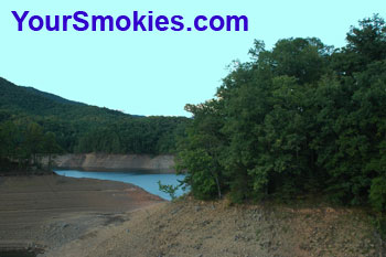
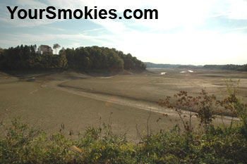
North Carolina Fontana Lake low water levelTennessee Douglas Lake low water level

Pictured above on the left is the Fontana Lake area in Fontana North Carolina which is at the south end of the National Park and on the right is Douglas Lake that is just north of the park in Sevierville and Dandridge Tennessee. Not only do these lakes provide water but their dams generate hydroelectric power which serves the Smoky Mountain Region.

While these lakes are normally lowered in the wintertime by the Tennessee Valley Authority (TVA) by purposely letting water through the spillways of the dams, there is obviously no need to do so this year.

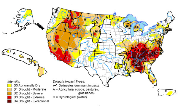
North Carolina and Tennessee areas affected by this year's drought

As seen by the chart above, not only are the Smoky Mountains of North Carolina and Tennessee affected by this year's drought, but large sections of the continental US are as well. Clicking on the map above will open a map of the drought effects as well as those regions not effect in the entire United States including Alaska and Hawaii.

Businesses as far north as Vermont are complaining the this years 2007 fall leaf season is coming late and is not as showy as normal with many trees turning brown before reaching the vibrant read, pinks and peach colors of most years.

Experts blame the lack of moisture on the phenomena and show the clear correlation in the past few years' weather warmer dryer weather and the decline in some of the forests natural food stock production for wild animals and farmed crops.

A direct effect of the drought is clearly seen in the Great Smoky Mountains National Park where normally vibrant lush creek and stream beds have been dry for months. Fishermen are working hard to find fish and obviously so are the National Parks inhabitants such as Black Bear, raccoons, birds, predatory fish and a host of other animals that depending on aquatic creatures to sustain them.

Groups such as Friends of the Smokies worked hard with a Brook Trout restoration project and between the loss of Eastern Hemlock Trees that normally shade streams to keep them cooler and help maintain moisture in the important breeding areas for fish due to an invasive pest called the Hemlock Woolly Adelgid and the current drought some of their intense well meaning effort may be for naught.

Further evidence of the drought in the Great Smoky Mountains National Park is the fact that there is a 23 mile stretch of the Appalachian Trail (AT) where there is virtually no water for backpackers and campers between the Derrick Knob Shelter and the Fontana Dam.

There are also backcountry campsites and shelters in the national park that are dry: sites 4, 5, 6, 7, 16, 21, 26, 35, 42, 113, and the hikers shelters: Double Spring Gap, Mollies Ridge, Russell Field Silers Bald and Spence Field.

As the drought continues more campsites and shelters may run dry and even with sites that have water a quart sized bottle may take 5 or more minutes to fill.

Fruits, nuts and vegetation are also sparser than normal which can lead to a difficult winter for animals that depend on these natural food stocks. Black Bears in the GSMNP are normally active in the autumn season gathering up and eating as much food stocks as possible so that they may make it through the winter where traditionally they are not active and may or may not hibernate through the winter.

While tourists love the blue skies and nice warm, dry weather we are experiencing in the Smoky Mountains of North Carolina and Tennessee, we locals are praying for a break with some sustained moderate volume rain. Heavy rainfall will just run off causing erosion and flooding but if the rain volume is relatively light and lasts for a while it can percolate better into the aquifers.

This year's drought in the Smokies won't be forgotten by locals residents and anyone visiting the region.

Saturday, September 22, 2007

Drought conditions still affect the Great Smoky Mountains National Park

Water is scarce in some parts of the Great Smoky Mountains National Park (GSMNP) and the Appalachian Trail which can spell serious trouble for hikers and campers who plan on normally abundant water sources.

We have seen our river and lake levels at extremely low levels this year due to an extended drought for this entire year. Springtime in the Smokies saw excessive wildfires in and around the Great Smoky Mountains National Park and surrounding state parks and forests.

Now to compound the water problems in the Smokies large areas of the park are "dry" where most or all of the free running springs won't allow any relief to parched hikers - or local animals.

In particular on the Appalachian Trail between Shuckstack Mountain north of Fontana Dam to Spence Field there is approximately a 16 mile stretch that is dry as well as the Russell Field Shelter and Mollies Ridge Shelter and backcountry sites 4, 5, 6, 7, 16, 26, 42, 113.

Smokies plant life

Today's gentle rain falling in parts of the Tennessee Smoky Mountains might have brought some mild relief from the warmth of the afternoon but other than making the leaves on the ground a little less crunchy while hiking and making for some nice raindrops on a leaf pictures (see above) it was not enough to elevate the issues with drying up streams, lakes and wells in both Tennessee and North Carolina.