Friday, November 13, 2009

Elk poaching takes place in Cataloochee Valley in the Great Smoky Mountains national park.

Those of you who follow me on Twitter know how near and dear the Elk in the Great Smoky Mountains national park are to me and of course the tens of thousands of other park visitors a year who come to the Cataloochee Valley just to see our elk.

Elk poaching takes place in the Great Smoky Mountains national park.

Unfortunately this morning someone well within the national park boundaries in the Cataloochee Valley decided to poach one of our beloved Elk which was one of the first elk released in the park, 13 year old Bull #21 pictured above.

This person who committed this cowardly act not only took this animals life away but took from all of us a magnificent beast. Elk are now able to roam the Great Smoky Mountains which have not heard the bugle of a wild elk for more than 100 years due to over hunting and habitat destruction because of a great investment and time and money from private sources given graciously to the park.

For those of us who love the Great Smoky Mountains national park the elk have become intimately intertwined with this beautiful place since their experiment introduction in 2001 and the herd has grown from 52 head to an estimated 105. The long term prospects for this experimental reintroduction of elk in the Smokies looks fantastic.

Poaching of natural and cultural artifacts is a serious problem in all of our national parks. Poaching in the Great Smoky Mountains national park and the adjoining Blue Ridge Parkway is most commonly to plants such as ramps, ginseng, and wildflowers such as lady slippers as well as wildlife most commonly black bear and deer.

More than 80 park volunteers who love the elk and I work in the Cataloochee Valley of the Great Smoky Mountains National Park in a program called the Elk Bugle Corp offering educational information to visitors about the elk and the GSMNP, help with traffic management and work to maintain a safe distance between visitors and our beloved elk and black bear.

So that some good use comes out of this cowardly crime, it would be great if this animal was mounted for display in the new Oconaluftee visitor center being built or the Sugarlands visitor center museum rather than just dump the animal's body after the forensic evidence is gathered to prosecute this criminal. At least people can then see up close one of these magnificent animals we have so much invested in.

I urge anyone who has any information about this or any wildlife crime in the Great Smoky Mountains National Park to call the GSMNP Main Number at park headquarters (865)436-1200.

Related Elk in the GSMNP Stories

Wednesday, November 11, 2009

Cades Cove Loop Road and Greenbrier Road are closed. Other local roads flood due to high water

Cades Cove Loop Road and Greenbrier Road have both been closed today due to high water on numerous places from the past 30 hours of rain. Since close to 3 inches of rain has fallen in some areas creeks streams and rivers are spilling over their banks creating a mess for many on the Smoky Mountains.

There have been numerous traffic accidents in the Gatlinburg - Pigeon Forge - Sevierville area and a flood watch is in effect in Newport until 7 pm as the Pigeon River is expected to create flooding issues.

To make matters worse there is a wind advisory in effect today until 4 pm tomorrow so expect that trees will fall because of the saturated ground and high winds creating more power outages and telephone and internet service interruptions.

The Great Smoky Mountains national park is faring better than expected as other roads in the park have not been closed yet and though all the branches, creeks, streams and rivers are flooding they are yet to create any property or safety issues other than for those who will kayak or attempt to cross them in the dangerous state.

While it is possible that Cades Cove Loop Road may reopen today if the high waters recede, it is doubtful that Hyatt Lane, Sparks Lane, Forge Creek Road and Parsons Branch Road will open right away as vehicles driving over these gravel roads when they are saturated do serious damage to the roadway.

Greenbrier Road is closed right now and may reopen today, but the section of roadway to the Ramsey Cascades parking area will take at least a day before the water recedes enough for it to reopen.

Friday, November 06, 2009

Closed section of Foothills Parkway West will see some construction traffic for 6 weeks.

One of hidden secrets of the Great Smoky Mountains national park are the 2 incomplete sections of the Foothills Parkway off 321 which has some stunning vistas and hikers, bicyclists, horseback riders and even leased dogs are allowed.

Both of these long "trails" offer visitors a chance to explore nature for long distances with a gradual grade which is very accessible for those how may have problems with conventional hiking trails, want to avoid crowds or who are higher functioning persons with disabilities.

Unopened Section of Foothills Parkway

From November 12th through December 22nd on the far eastern side of the 9 mile section of the Foothills Parkway by Walland core drilling will be taking places so hiker and bikers need to be aware that this normally traffic free area will see some construction vehicles driving to and from the drilling sites.

I would suggest that anyone especially those who live in the area who has not hiked the incomplete sections of the Foothills Parkway does so before it is finished and open to vehicular traffic.

Related Smokies News Stories

Wednesday, November 04, 2009

Controlled burns to take place in Cades Cove section of the Great Smoky Mountains national park.

Cades Cove in the north western section of the Great Smoky Mountains national park will be ground zero for 3 planned controlled burns this week performed by national park service firefighters as a cost effective method to keep the historic fields in the valley from becoming a forest.

Prescribed burns in Cades Cove generally take place in March but due to the Cades Cove Loop Road repaving next year which will close the road, prescribed burns will take place if weather conditions permit today through Friday.

Today the park plans on burning several tracts of land in the Cades Cove Valley west of Hyatt Lane close to where prescribed burns took place this spring. Before setting the larger blaze containment areas have been set by mowing the grass around where the burn is to take place.

If all goes well tomorrow through Friday the next set of controlled wildfires in the Great Smoky Mountains national park will take place in fields between Parks and Hyatt Lane.

While these burns should not effect traffic along the Cades Cove Loop Road it is possible to road will be closed for safety reasons. It is also possible either Hyatt Lane or Sparks Lane will be also closed in the next 3 days but more than likely the only effect the prescribed wild fire will have on visitors in Cades Cove is the sight and smell of smoke.

The Great Smoky Mountains national park has about 950 acres of fields in the Cove visible from Cades Cove Loop Road mowed a year and another 1,000 acres that are less visible are kept from being claimed by forest burned or mowed on a 3 year rotation.

Thursday, October 29, 2009

Landslide in Great Smoky Mountains national park cleared but clearing I-40 will take many months.

This has been some leaf season in the Smokies! Multiple rock and landslides within weeks create traffic nightmares for many, but fortunately yesterday's landslide in the Great Smoky Mountains national park took the park and Blalock Construction less than 24 hours to clear but the I-40 landslide only 3 miles from the Tennessee and North Carolina border will take until March 2010 or longer.

This summer we saw 2 rock slides occur along Little River Road which took days to clean up so that the road could be reopened so it was a very pleasant surprise to see how fast the main East West road in the Great Smoky Mountains national park reopened however those who wish to take I-40 from North Carolina will have to wait far longer before they can avoid detours. The real disaster for drivers will be when Newfound Gap Road (US 441) closes due to ice and snow in bad weather which is a very common occurrence.

There was another closure due to at potential landslide this moth along the Blue Ridge Parkway which has also cause drivers to have to deal with lengthy detours right when the fall season colors were at their peak along the parkway.

Related Landslide and Rockslides in the Smokies Stories:

Sunday, October 18, 2009

Newfound Gap road reopens in the Great Smoky Mountains national park.

As the weather improves over the Great Smoky Mountains national park so do the traffic conditions because the Great Smoky Mountains national park has just opened back up Newfound Gap Road the main thoroughfare between Gatlinburg and Cherokee.

It is possible that with this evenings cold conditions will close the road as it refreezes.

Snow Closes Roads In The Great Smoky Mountains National Park.

A light dusting of snow in the upper elevations yesterday afternoon which fell through some of the evening first closed Clingmans Dome Road and then Newfound Gap Road US 441 which runs through the Great Smoky Mountains national park connecting Cherokee North Carolina with Gatlinburg Tennessee.

Other road such as the Blue Ridge Parkway, Old 284 and Cove Creek Road running to Cataloochee all saw accumulation and slushy icy conditions. Last evening a truck needed assistance to make it up and out of Cataloochee but not without fishtailing a few times and cosmetically damaging its tailgate.

Wet conditions made for numerous accidents in and around the Great Smoky Mountains national park. Drivers are reminded to obey speed limit and if conditions require, to drive even slower. During leaf season especially when there is the added beauty of snow in the mountains drivers may become distracted or even slow down and stop in the roadways to take pictures which is prohibited.

This is the first day of the season that snow has been sticking and ice has been forming on roadways as pictured below on Cove Creel Road yesterday at around 3 pm.

Right now the snow and ices is melting quite well and crews are right now sanding the Newfound Gap Road which may open up before 11:00 am. As temperatures cool down later in the day and the melting snow and ice refreezes, it may have to close again.

Thursday, October 15, 2009

12 miles of Blue Ridge Parkway in Mount Pisgah - Asheville Area Closed Due to Landslide Danger

Weeks of rain has taken its toll on the Blue Ridge Parkway at what is the worst possible time for a closure of a stretch of roadway in the Mount Pisgah Asheville area as peak leaf season is coloring the slopes and valleys of North Carolina.

Crews are working right now to erect temporary barriers in hopes that the most of the roadway will be opened back up Friday for the 2nd weekend of peak leaf season on the Blue Ridge Parkway. The area that will remain closed would be the Ferrin Knob Tunnel Number 1.

The slope that is causing all this grief has been closely monitored by the park service since it first failed in 2002 and had been repaired and according to Bambi Teague, the Blue Ridge Parkway's chief of resource management "It has been slipping and sliding since then, but in the past three weeks, it has been moving way more than anyone expected it would" which prompted the closure.

Blue Ridge Parkway in North Carolina fall color has painted the slopes and valleys in reds, yellows and oranges.

The picture above was taken 2 days ago on the Blue Ridge Parkway in North Carolina and shows how fall color has already painted the slopes and valleys in reds, yellows and oranges between US 441 and US 19. This stretch is unaffected by the closure and leaf peepers traveling from Asheville should use US 276 near Brevard or NC 151 from Candler.

Sunday, September 27, 2009

Greenbrier section still closed but Cades Cove reopens as Great Smoky Mountains National park cleans up from flooding and storm damage

While the storm that drenched the Smoky Mountains was not packing much of a punch dropping from 2 to just less than 3 inches of rain in the past 24 hours in areas of the park, the saturated ground and rain swollen rivers could not handle any more and minor flooding was widespread in areas in and around the Great Smoky Mountains national park.

The Little Pigeon River created the most damage in the Great Smoky Mountains national park as it washed out an area of roadway along Greenbrier Road near the bridge to Ramsey Cascades where Middle Prong runs into the Little Pigeon River.

The video below shows the Little Pigeon River following over its bank and it effects were felt far downstream in the residential areas some of which had minor evacuations.

The Little River which flows out of Elkmont was rising quickly promoting an evacuation of the Elkmont Campgrounds in the Great Smoky Mountains national park and further downstream created problems for campgrounds outside the park and resident in Townsend and Walland. The Campground has been deemed safe and was just reopened.

In Cades Cove Sparks Lane which notoriously gets flooded was closed first followed by Hyatt Land and then the entire 11 miles of the Cades Cove Loop were closed as water stared building up in the back end. Cades Cove Loop has just reopened but Sparks Lane, Hyatt lane and Rich Mountain Road will remain closed until they dry out so that passing vehicles will not damage the road surface.

The Chimneys Picnic Area was also closed last night as rising waters from the Little Pigeon River started to flow over the banks.

Crews will be working today in the park surveying and cleaning what appears to be minor damage. Hikers should report any large downed trees or washout in back country but expect to have to climb over under or around obstructions in the trails for at least a few days.

Based upon the extent of the damage on Greenbrier Road reported to me by eyewitness yesterday don't expect Greenbrier to be open past the Ranger station for at least a day or 2. Hopefully while they have dump trucks in the area they will fix some of the preexisting immense holes in the road surface right now.

Tuesday, September 22, 2009

Last Chance to Hike or Bike Cades Cove without Traffic until Repaving is finished in 2010

I love hiking and driving in Cades Cove. Problem is millions have as well for the past 39 years leading to the complete degradation of the Cades Cove Loop Road which will be broken up and repaved next year so this Wednesday is your last chance to hike the road without traffic until at least late May.

Cades Cove Loop road is closed to automobile traffic until 10 am on Wednesday and Saturday mornings from spring until late September so that pedestrians and bicyclists can enjoy this spectacular place without the noise and annoyance of car and motorcycle traffic.

Starting on March of 2010 Cades Cove loop Road will be closed to all traffic - cars, bikes and all pedestrians - in order for the roadway to be broken up and pulverized, new concrete poured and then the road will be surfaces with asphalt. While the Great Smoky Mountains national park is hopeful that the job will be completed by Memorial Day although weather will determine how fast this job can be completed.

The new Cades Cove Loop Road will not be widened and a total of 12 pull offs were proposed by the park. Rumors are floating around that the road will be made harder to park alongside of except at designated pull offs.

Hiking or biking in Cades Cove in the morning is just such a magical time. Expect cool comfortably temperatures, a hint of mist in the year, easy wildlife sighting of turkey, deer, bear and maybe even a coyote and the magical lighting that photographers refer to as "the golden hour".

I particularity like walking the 11 miles of the Cades Cove Loop road rather than riding a bike. It is just so much more intimate to be walking quietly along this road as the beauty of the cove and its inhabitants unfolds before you at every twist and turn of this historic road.

From wide vistas of meadows framed by mountains to walking through tunnels of trees that envelop you and block out the sun, every footstep is in another chance for you to intimately experience adventure and beauty.

Hiking and Biking the 11 mile Cades Cove Loop road

Sunrise will be at 7:31 am tomorrow morning and it takes around 3-1/2 hours to hike the loop quickly so I count on 4 to 4-1/2 hours to take my time and take photographs and "smell the roses" along the way.

Cars are allowed to drive into the Cades Cove Loop at 10 am and won't reach the back end of the loop until around 10:30 - 10:45. Hiker and bikers need to park at the orientation shelter at the beginning of the Cades Cove Loop until the parking area fills at which time you will be directed to park near the Cades Cove Riding Stables.

I will be leaving at 6:45 - 7 am from the orientation shelter to I will be already be past the John Oliver cabin past sunrise. Anyone looking to join me is welcome and should comment here or twitter me their intentions.

Related Smokies News Stories:

Friday, September 11, 2009

Mountain Life Festival at the Mountain Farm Museum in Oconaluftee Area of Great Smoky Mountains national park

In the upper elevations of the Great Smoky Mountains national park there is a touch of color and the heat has broken and even in the valleys the heat of summer has been broken so the annual Mountain Life Festival at the Mountain Farm Museum in Oconaluftee is right around the corner.

Come to the farm museum on Saturday September 19th from 10 am to 4 pm and learn why leather britches are not pants, what carding means when it has nothing to do with ID and what it's like to make your own soap while listening to great Appalachian style music - all for free!

While I am sad to see what for me signals for me the end of summer, this is one annual event in the Great Smoky Mountains national park I have not missed for years.

The location of the Farm Museum is perfect in beautiful green valley alongside the Oconaluftee River surrounded by low mountains that will only have a hint of color just a minute inside the park boundary at Cherokee.

hands on demonstration of home life in the 1800s

Expect the hands of time turn back more than a hundred years and see interesting live demonstrations by park staff and volunteers such as lye soap making, hearth cooking, food preservation, broom making, quilting, blacksmithing, chair bottoming, along with apple butter and apple cider making. You will get to sample warm cider too!

A special edition this year to help celebrate the parks 75th anniversary is a showcase Appalachian folkways along with historic artifacts and photographs from the national park's collection will also be on display to help pay tribute to the former resident who lived where the park now stands.

hands of time turn back more than a hundred years and see interesting live demonstrations by park staff and volunteers

Corn husk dolls, hominy making, old time toys and other interesting demonstrations about what home life was 100 years ago in the Great Smoky Mountains will be going on around the farm museum.

You can also learn about the more than 40 types of apple tress the Cherokee and the early settlers grew from Ron and Suzanne Joyner from Big Horse Creek Farm in Ashe County, NC. When I interviewed them in the past they were a wealth of knowledge and they presently have a nursery with more than 300 varieties of custom-grafted heirloom apple trees.

In the farm itself, you can watch an almost 40 year old tradition of the Great Smoky Mountains national park: the making of sorghum syrup. The Appalachian early settlers did not have table sugar and they grew their own sorghum and with a horse-powered cane mill and wood-fired cooker made this important food stable.

40 year old tradition of the Great Smoky Mountains national park: the making of sorghum syrup

Students, staff, and volunteers from Swain County High School through a cooperative agreement with Great Smoky Mountains National Park and the Great Smoky Mountains Association will be feeding the press which is pictured above and making the sorghum syrup.

Through all the celebrating at the Mountain Farm Museum in Oconaluftee, don't miss the musical entertainment by Marshall Crowe and the Bluegrass Singers.

Bedsides the event, take some time to stroll down the Oconaluftee River hiking trail which is one of the 2 trails in the park that allows well behaved leashed dogs and stroll around the farm with its historic buildings and picturesque landscape.

Wednesday, September 09, 2009

Bear Spray: Now Legal to Carry and Use in the Great Smoky Mountains national park.

Though I was waiting for months for the official announcement that bear spray would be legal in the Great Smoky Mountains national park, it was a sharp reader of this web site that brought to my attention the fact that the National Park web site now states bear spray is allowed in the GSMNP.

Months ago I started and became the center of a huge controversy about bear spray when it was brought to my attention that Bear Spray was illegal in the Great Smoky Mountains national park. Questions about misleading, conflicting and confusing visitor information as well as selective enforcement made matters worse.

Bear spray is far more effective that firearms are in a bear attack which by that way, even though there are more than 2 bear per square mile is extremely rare in the Great Smoky Mountains national park.

Since bear spray is far more effective than guns and the chances of collateral damage is far lower, it made perfect since to legalize bear spray since firearms will be allowed in national parks in February 2010.

While I was advised by park officials in late spring that the bear pepper spray law was going to change, I waited until the official announcement from the park to advise my readers about the change in the bear spray law as I did not know exactly when it would become legal.

No news of the change in the bear spray law was ever released publicly; instead a paragraph about bear spray and its legality and use in the Great Smoky Mountains national park was inserted in the GSMNPs hiking page.

Bear Spray (pepper spray formulated for bears) should be only used in an emergency against an attacking bear and not used to keep bear away from campsites or other place you wish to keep bear away from. Spraying an area with bear spray may even attract bears them rather then repel them as they will want to examine what the strange scent is and where it is coming from.

Bear Pepper Spray is only allowed in the Great Smoky Mountains national park for "the strict purpose of protection against bodily harm from aggressive wildlife". It must also contain between 1% to 2% of the active ingredients capsaicin and related capsaicinoids and be commercially manufactured and labeled as "Bear Pepper Spray".

I stumbled into something that made some people working in the park and some locals who refused to comply with the law all along unhappy. While my tenacity about getting to the bottom of this matter may have angered some, they do know my love for the park and how resource protection and public safety are for more important to me than not making waves. I hope that those who I may have aggravated understand my good attentions.

Though I plan to never use it, bear spray will now be part of my hiking gear. I hope that people who will purchase bear spray will learn about it, try it and only use it when absolutely necessary (which in the GSMNP should be almost never).

Just because you are allowed to have a can of bear pepper spray when hiking in the Great Smoky Mountains national park does not mean that you can ignore food storage rules, comply with staying away 50 yards away from bear or using common sense around wild animals.

Just as bear spray is now legal in the Great Smoky Mountains National Park, if abused the park may take this right away just as they had to remove chain link fences from shelters as people abused the fences and would throw food out for bears. Be responsible!


Related Stores about Bear Spray and Black Bear

Wednesday, September 02, 2009

The Great Smoky Mountains National Parks 75th Anniversary Rededication and Newfound Gap: Great Memories for a Lifetime

I have been waiting for this day when the Great Smoky Mountains National parks would have a rededication ceremony and the Roosevelt Monument at Newfound Gap in celebration do the parks 75th Anniversary for years, and with all my expectations I can't believe I was not let down.

This dedication ceremony was to be a modern day interpretation of the 1940 dedication event in the Great Smoky Mountains National Park which was attended by president FDR, was the grand finale of the major events the GSM national park was hosting for the 75th anniversary of the formation of this park.

modern day interpretation of the 1940 dedication event in the Great Smoky Mountains National Park which was attended by president FDR

Almost 2,000 people attended the Rededication Ceremony held at the Roosevelt Monument which straddles the Tennessee and the North Carolina border in the Newfound Gap parking area of the Great Smoky Mountains national park.

Many of those who attended this historic event have deep roots in the Smoky Mountains and most of them where either born in what was to become the Great Smoky Mountains national park or are descendants of those who lived here.

Almost 2,000 people attended the Dedication at the Roosevelt Monument in the Newfound Gap parking area of the Great Smoky Mountains national park

Some of those very hardy men who built the Great Smoky Mountains national parks trails, bridges and roads who were members of the Civilian Conservation Corp (CCC) attended this event.

By now these men have become old familiar faces to me as they have been guests of honor numerous here in the past year such as at the CCC dedication ceremony at the Sugarlands Visitor Center where a plaque honoring the Civilian Conservation Corp was unveiled and at the groundbreaking for the new Oconaluftee Visitor Center.

As with all the other ceremonies, CCC corpsman Clarence Allison, the 3rd man down in the picture below wore his original uniform and hat.

Among the honored guests at the dedication ceremony were these men who worked for the CCC

Today some of those who were here for that historic occasion 75 years ago proudly wore ribbons as well as those who lived in what is now the park and those who built the roads, bridges and more than 800 miles of hiking trails that crisscross the park.

Lots of changes have occurred in the Great Smoky Mountains the past 75 years since the men on the CCC help turned it into the land stunning place it now is and most have them have been for the good of the national park.

Technology allowed us to make cell phone calls, check our email, update our Twitter accounts or transmit a signal via satellites so that people outside the park could see what was going on. Just think at the 1st dedication in 1940 wire was run in trees and across bushes and up the mountains in order to transmit this historic occasion.

100 old Gudger Palmer had his roots in Big Cataloochee in North Carolina before he was forced to move out of the park at 25.

75 years ago when 100 old Gudger Palmer (pictured above) was only 25 and lived in Cataloochee North Carolina, there used to be barely any black bear, wild turkey and white deer inhabiting the area which just became the Great Smoky Mountains national park. These and many other animals now flourish and even the casual observer in the park should see them most of the year.

Then there are the animals that have been wiped out of existence in what was once more than 6,000 private tracts of lands. Today the park service has brought the river otter, peregrine falcon and my favorite: the North American elk back into this area and they are all now thriving in this beautiful biosphere.

While this was a day for historic speeches made by politicians promising to make things better and of course the thrill of seeing Dolly Parton perform live, the Great Smoky Mountains National Park itself was the star of the day.

Dolly Parton receives a bouquet of flowers from Dale Ditmanson superintendent of the Great Smoky Mountains national park while Secretary of the Department of the Interior Ken Salazar and NC Governor Bev Perdue look on

As our bus pulled up past the rain clouds up to the Newfound Gap Parking area, a lone tree just below the road displayed red and yellow tinges on some of its leaves - a gentle sign of fall color that would soon grace the Smoky Mountains.

As we disembarked from the shuttle the cooler air laced with the smell of fir washed over us moved the 3 American flags and the North Carolina and Tennessee state flags on top of the Roosevelt Monument wave in the wind. The only other decorations were 7 white and blue banners draped over the monument which also came alive as the wind came across the gap.

Governor Bev Perdue said North Carolina working the crowd and Newfound Gap in the Great Smoky Mountains

Sure the 75th anniversary of the original dedication of the Great Smoky Mountains national park was a great opportunity for politicians to press flesh with constituents and get to work in some impressive sound bites, nothing could beat the parks performance as the weather cleared up just as the program began and deteriorated with clouds moving in as Dolly Parton closed the event with her last song.

I had been waiting for this event for years all the while reflecting how wonderful this park is and I was not disappointed. I guess I must now look forward to the 100th anniversary dedication and hope that I will still be hiking as I do now in my 70s and reveling in the Great Smoky Mountain national parks beauty.

Sunday, August 30, 2009

Rescue of a Lost and Stranded Hiker in the Great Smoky Mountains National Park Concludes

Lost and then stranded experienced 70 year old hiker Albert Morgan Briggs who was stuck atop Porters Mountain for almost a week deep in the Great Smoky Mountains national park was rescued early this morning by a Tennessee Highway Patrol helicopter and taken to the Little River Ranger station where he was debriefed by park rangers about his ordeal and later picked up by his family and taken home.

What happened the past week to Albert Morgan Briggs who is a park volunteer and presently works in the parks backcountry permit office and prior to this was a ridge runner on the Appalachian Trail helping maintain the trails and guiding hikers, is both a tale of what hikers should and should not do.

Fortunately even though Morgan had what was a physically trying and well as emotionally draining week, other than a light sunburn and filthy clothes he was wearing from bushwhacking in the deep rhododendron thickets and climbing his way up about 1,200 feet to ridgeline below the Peak of Porters Mountain which is barely a few feet wide, he was in great shape and spirits.

When I was interviewing the crew of the helicopter that rescued Mr. Morgan, they all expressed concern about the conditions and the ruggedness of the backcountry he was stranded in. The crew also described that they could not believe how narrow the ridge was where Moran Briggs tent was precariously perched and how exposed he was.

If the helicopter could not have hoisted off the ridge on Porters Mountains, there would have been no room to put the bird down and the only way they would have had left to rescue him would have been for the ground crew to climb 1,200 feet practically straight up to retrieve him. The park service suggested that chainsaws would have probably been needed than in order to cut through the thickets.

Amazingly one of the teams of rangers on the search and rescue mission this week was less than 50 yards from Morgan Briggs and they did not realize the missing hiker was so close to them.

This distance was confirmed by checking the data of the ground crews GPS unit and according to North District Head Ranger Steven Kloster, the Porter Mountain ridgeline was already in today's search plan even if Morgan had not been spotted by observers on the Appalachian Trail (AT) and their sighting confirmed by a helicopter yesterday.

While I was able to gather information for this story from many firsthand sources, Morgan would not speak to any of us at the press conference but he did promise to give us the chance to interview him at a future date so at least we will have a more detailed picture of what initially happened and well as his state of mind during the week long ordeal.

I was in a rush to report all details of this story upon his rescue, but I held off as more and more questions and thoughts came to mind and more details have come to light about his ordeal. Many sources I have seen reporting this story had wrong information such as elevation gains and distances, made wrong conclusions and left out important facts.

Morgan's Planed 4 Day Hike in the GSMNP

Day 1: Hike from the Trailhead in Greenbrier where he was dropped off just 3.5 miles on the Porters Creek maintained hiking trail to backcountry campsite #31 where he would spend the night.

Day 2: Hike his way through brush on an unmaintained unofficial trail referred to as a "manway" where he would have to work his way through drainages making crossings in rain swollen creeks and streams, around fallen trees and through tough brush including rhododendron thickets and thorny briers that you would not normally encounter on a maintained official park trail.

Morgan would work his way up a gain of 2,000 feet and eventually end up along the Appalachian Trail which runs across most of the Great Smoky Mountains national parks highest points along the Tennessee North Carolina border for about a mile to a lean to along the AT named the Icewater Springs Shelter.

Day 3: Hike the 6 miles from the Icewater Springs Shelter along the AT and the Boulevard Hiking Trail to Mount LeConte where he would spend the night at the Mount LeConte Shelter.

Day 4: Hike down Mt LeConte to hitch a ride to Gatlinburg and take the trolley home to Pigeon Forge. No one other than Morgan is sure which trail he wished to take back but it is believed his choices were Alum Cave Trail (about 5 miles), Rainbow Falls (about 6.5 miles) or the Bull Head (about 6.5 miles) hiking trails.

Morgan's Planed Hike in the Great Smoky Mountains national park

What happened on the hike:

Day 1: Morgan hiked in and spent the first night as planned in campsite 31.

Day 2: He was last seen by other hikers this day at the campsite where after waking and packing his gear, he started the off trail portion of his hike he made a wrong turn and got disorientated and lost.

Rather than following the stream out to the road about 3 miles to the north he decided to climb up a little over 1,000 feet to the top of Porters Mountain where he pitched his tent and remained the next 6 days until he was rescued by helicopter.

So what went wrong and what went right in Morgan Briggs preparation, hike and subsequent rescue in the GSMNP?

What went right:

1) Though this story concluded with the safe return of a hiker who was lost and then stranded for a week with limited food and water and no way to communicate with the outside world, the timing of this hike more than likely made the difference between life and death.

If this fateful hike in the Great Smoky Mountains national park was a few weeks from now when the cold weather sets in, the risk of exposure would have been enormously increased - or if it was a few weeks earlier when it was very hot, humid and there was no rainfall Morgan could have suffered from severe dehydration or could have had a heat stroke and died.

The fact that he was so exposed on a high ridgeline, during any thunderstorm a bolt of lightning could have dealt him a lethal blow.

The weather also cooperated on the day of his rescue as the fog just lifted and visibility and wind speed just turned conducive for an extraction by chopper rather than a more prolonged and dangerous extraction by climbers.

2) Morgan Briggs told people where he was going and when he was due back. He filled out the necessary permits so he could be tracked.

Once he was overdue on Tuesday his family was concerned and eventually contacted the park service and the search for Albert Morgan Briggs began on Wednesday (Day 5).

3) When Morgan was lost on day 2 of the hike, he had worked his way to higher ground where he stayed put.

His highly visible yellow tent/tarp was seen by searches on the ground about a mile away on the AT because he was so visible and out of the cover of the forest canopy.

Had his tent/tarp been a color such as green or with camouflage pattern such as I often use, he may never have been spotted by the ground crew or the helicopter that eventually dropped him supplies.

4) When Morgan knew he was lost he started to ration his food which consisted of Spam and canned peaches.

Unfortunately both foods would increase his dehydration and subsequent thirst since the Spam is loaded with sodium and the peaches are in sugary syrup.

5) Though Morgan was working his way through mud and streams, where he ultimately ended up stranded there was no source of water so he ran dry.

Using tent flaps and a tarp he collected rain water from the daily rain we had last week in the Smokies.

While he was lost and stranded in the Great Smoky Mountains national park, dehydration was the largest danger he faced that could have proved fatal.

What went wrong:

1) Hiking on manways is not prohibited but is strongly advised against by GSM park officials.

Some manways such Pinnacles Manway in Greenbrier is in a similar condition to many maintained trails other than a few blow downs and is very clearly defined.

The manways that Morgan was hiking on are not clearly defined, in poor condition and have elevation gains that are unsafe given the condition of the trail.

This is not a manway that should ever be hiked solo and if you would do so, it is better to do it in the winter when the lack of most of the forest canopy makes following the trail and navigation with a GPS much easier.

This particular manway I have described numerous times as the only major manway in the Great Smoky Mountains national parks I have never hiked on because of the inherent dangers.

Hiking manways or off trail requiring bushwhacking does significant ecological damage to potentially endangered or rare plants, fragile habitats and their inhabitants.

Responsible off trail hiking should be done in the late fall, winter and early spring when the ground-cover and the understory is dormant so you are reducing your environment impact and it's also easier to read the terrain.

2) Morgan did not bring along any communications and navigation electronics.

A cell phone with Verizon service may have actually worked in his location, a GPS may have worked well enough to keep him from getting lost, a walkie talkie may have allowed him to communicate with another hiker in range on the AT and if all else fails he could have used a personal safety beacon as soon as he was stranded and he would have been rescued in hours rather than on day 8.

I tell everyone to never count on electronics for your survival when hiking and honesty hiking on marked and maintained trails you should not even need them, however when you hike solo on a dangerous unmarked trail it is ill advised to not have what is basic electronic safety equipment.

Any serious hiker going solo into a situation like this should never go hiking without a personal locator beacon.

ACR ResQLink 406 MHz Buoyant Personal Locator Beacon

ACR ResQLink 406 MHz Buoyant Personal Locator Beacon

Rigorously tested in Alaska, the ACR ResQLink+ 406 MHz Buoyant Personal Locator Beacon provides a safety net in case things take a turn for the worse at sea. Three levels of integrated signal technology-GPS positioning, a powerful 406 MHz signal, and 121.5 MHz homing capability-combine to relay your position to a worldwide network of search and rescue satellites. Small enough to carry in a pocket, clip to a backpack, or store inside an inflatable life jacket.Features include waterproof construction and a built-in strobe light that provides visibility during night rescues. Runs up to 30 hours. Even in extreme conditions, the ResQLink+ activates easily. Just deploy the antenna and press the ON button.


3) A low tech visual signal method could have been used to call attention to him and his location: Fire and its subsequent smoke.

Though it is illegal to make a fire when in the national park outside of a fire ring or BBQ in a picnic area or campgrounds, in an emergency, fresh leaves burning would have brought attention to his position much faster.

Since he was camping and planning to be in shelters for days one would assume here would have brought along what it took to make a fire each night such as a lighter, matches or flint.

A camp fire with damp leaves would have made a smell and visual indicators of light and smoke which could have easily been seen or smelled by his rescuers.

Another low tech signaling device would be a mirror or anything reflective could have also been used to gain attention such as a used Spam can and lid or the can from his peaches.

4) Morgan did not have or use a signal whistle or air horn.

I swear by my trusty Storm Safety Whistle which can be heard for a half a mile or more in the conditions Morgan was in. It's a cheap low tech gadget that any hiker should have at all times - short hike or overnight trip.

A Storm Safety Whistle is louder than any other whistle and it even works underwater. Best investment under $10 you can make in saving your life and maybe even chasing an aggressive bear away.

Spend less than $12 and get a decent whistle, a signal mirror and a float, all of which take up almost no room in your pack (or pocket).

ACR Hot Shot Signal Mirror

ACR Hot Shot Signal Mirror

The ACR Hot Shot Signal Mirror is designed to provide optimum sighting spot and comes with a float and whistle. The second surface mirror is telescope quality for a bright, focused image. The buoyant float is bright yellow for easy location and the whistle meets USCG standards for audible alerting in low visibility conditions.


Air horns that use compressed gas come in small canister and are cheap and can also be heard for great distances. When the canister runs out of compressed gas you can put the horn in your mouth and blow.

Using a whistle or horn takes no energy as yelling does. Blowing a horn, whistle or shining a light in a "Short-Short-Short Long-Long-Long Short-Short-Short" SOS pattern is a universal cry for help in Morse Code.

Remember - searchers were as close as 50 yards away from him and he did not know they were there and they did not know he was there! Even a cheap whistle from Wal-Mart could have been heard at that distance.

Fortunately one of the search and rescue teams along the AT saw Morgan's yellow tent and were able to guide a helicopter to his location.

The helicopter returned with an extra sleeping bag, Gatorade, food and a park service radio so they were able to finally communicate with Mr. Briggs and prepare him for the rescue planed for the next day.

I would love to know that last night what Morgan was thinking that last night in his tent and when he finally woke up the next morning. We do know that pork chops were on his mind at some point because after leaving the national park with his brother along with his son and his family he wanted to stop by the supermarket for some to make for his first meal safe and sound back home.

Missing hiker Albert Morgan Briggs leaves the Little River ranger Station in the Great Smoky Mountains national park

This picture shows Morgan with his younger brother leaving the Little River ranger station along with all his hiking and camping gear which was also extracted from the top of Porter Mountain. Morgan looked well as he spoke quickly to park officials on the way to car.

His years of service were brought up by park officials including Park Superintendent Dale Ditmanson and how important the 2,000 plus park volunteers are to the Great Smoky Mountains national park. Morgan Briggs has helped countless other visitors to the park over the many years he has served the park and it was his turn to be helped.

Besides volunteers, there were 40 people who worked from the Great Smoky Mountains national park in the search and rescue teams. This did not include the 2 helicopter crews in 3 flights that were used to first find, then supply and finally to rescue Albert Morgan Briggs.

This was a well coordinated and expensive undertaking on the part of the national park service. Fortunately for the NPS and not the Tennessee tax payers, the cost of the helicopter retrieval off the mountain by a helicopter owned and flown by the Tennessee Highway Department, was paid for by the State of Tennessee.

As with any incident - especially one of this magnitude, there are lessons to be earned. While I travel with high visibility orange covers for my backpacks and 3 foil thermal blankets which would make a great signaling device, I am replacing my tent to one with a much higher visibility color based upon this incident.

While you need to careful anytime you hike in the wilderness, regardless of your hiking experience, my hope is that some of you will learn as I have and minimize the chance you can get lost and stranded in the Great Smoky Mountains and if you do survive until your swift rescue.

Related Stories:

Saturday, August 29, 2009

Missing Hiker in Great Smoky Mountains National Park Alive and Well but Not Out of the Woods - Yet

Tonight formally missing 70 year old hiker Albert Morgan Briggs is making his home in a tent perched about 4,800 feet up on Porters Mountain drinking Gatorade and eating food dropped down to him by helicopter this afternoon which also dropped a 2 way radio which he has now turned off to conserve battery life.

Though the weather was shaky all morning long and early in the afternoon, it finally cleared up enough that a helicopter was able to assist on the search for Mr. Albert Morgan Briggs who was backpacking and not been seen or heard from since Sunday morning.

It was just plain old perseverance which found Mr. Briggs as a search and rescue crew up on the Appalachian Trail (AT) noticed a yellow tent about a mile due north of Charles Bunion purchased on a rock outcropping which he was unable to move from due to the extreme terrain in the area (See Map Below).

Missing Hiker in Great Smoky Mountains National Park Alive and Well but Not Out of the Woods  - Yet

A helicopter was sent to his approximate location with the help of the spotters on the AT. Upon the helicopters arrival at about 4:15 Morgan signaled to it by waving his arms and with a red handkerchief that had with him.

Since there is no location near him the helicopter could set down, it flew back to the park headquarters where they loaded a pack with food, drink, a sleeping bag and a 2 way walkie talkie which was dropped to him as it was getting too dark for the crew on the ground to try to reach him in safety.

The rescue coordinators had a brief conversation on the radio with Mr. Albert Morgan Briggs to confirm that he was not injured and safe in his current location and that a rescue operation will take place to extract him from the ridge-line on Porters Mountain tomorrow.

Morgan's son has been contacted by the park service and advised of his status and the park services rescue plans.

Two concurrent rescue plans to extract Mr. Briggs are being put into action early tomorrow morning. The first rescue operation calls for 2 separate 4 man teams to be sent out to climb up to the peak of Porters Mountain to extract Mr. Briggs.

The second rescue operation which would be the preferred way to extract him but is dependent on the weather involves a Tennessee Highway Patrol helicopter which if it can fly will attempt to extract Morgan by hoist, pull him aboard and then land in the Sugarlands parking area by mid-morning.

I will be at vantage point on the top of mountain that looks directly out at the Porters Peak and may be able to capture the rescue if it is done by air. I will be twittering updates from my position at the peak of Shields Mountain in Sevierville.

Luckily though he put himself in a terrible position high atop an inaccessible ridge, at least he had enough experience to not try to get down and injure himself or be in a location in which he could not be spotted. Warm though wet weather has also keep the chance of exposure to a minimum and with the help of the additional sleeping bag he should be quite comfortable though anxious tonight.

Mr. Albert Morgan Briggs knows the park well as he was one of the national parks first ridge runners working along the Appalachian Trail and now works in the backcountry permit office in the Sugarlands visitor center just outside of Gatlinburg Tennessee.

Related Stories:

Missing Hiker in Great Smoky Mountains National Park has been Found Alive and Well.

After a very harrowing past few days, missing 70 year old hiker in the Great Smoky Mountains national park Albert Morgan Briggs of Pigeon Forge Tennessee was just found alive and well.

Rangers and volunteers have been looking since Wednesday for experienced hiker Albert Morgan Briggs when he was reported as overdue from a backpacking trip that started Saturday in the Greenbrier section of the Great Smoky Mountains national park.

A press conference will be held in about an hour at the national park headquarters and we will give the full details of Mr. Briggs rescue after the conference.

We have received numerous call and emails here about Mr. Morgan Briggs character by those who knew him and are so glad that the conclusion to the search and rescue had such a happy ending.

Friday, August 28, 2009

Search for Missing Hiker in the Great Smoky Mountains National Park is Still Unsuccessful

Though trackers for the Great Smoky Mountains National Park have searched through thick rhododendron thickets, sloshing through mud and scrambling up and around the numerous rocky outcrops and bluffs that create the 9 different drainages and other possible routes missing 70 year-old hiker Morgan Briggs may have taken since he was last seen in around campsite 31 in Greenbrier at the end of the Porters Creek Hiking Trail.

Search for Hiker in Great Smoky Mountains National Park Still Unsuccessful

Other searchers working in the Great Smoky Mountains National Park covered 8 miles of trail from the Appalachian Trail south into North Carolina and out to Newfound Gap Road at Kephart Prong Trailhead.

According to park officials search dogs may be used tomorrow to help find Morgan Briggs. Tomorrow calls for more bad weather but if it clears a helicopter may assist in the search even though with such dense cover as what the searchers are dealing with right now, the chance of spotting Albert Morgan Briggs is marginal at best.

Search underway in the Great Smoky Mountains National Park for missing experienced hiker Albert Morgan Briggs

One of the Great Smoky Mountains National Park's first Appalachian Trail Ridge Runner 70 year old Albert "Morgan" Briggs is the subject of a large search stared Wednesday by rangers and volunteers who have already hiked numerous trails and interviewed other hikers who may have seen this experienced backpacker who is now long overdue from a hiking trip.

Mr. Briggs of 1008 Trotter Way in Pigeon Forge started out last Saturday by hiking up the Porters Creek Trailhead where he was left off up to campsite #31 a group of hikers believe they had seen Mr. Briggs.

Mr. Albert Briggs planned on Sunday to hike up the manway another 2,000 feet in elevation higher up to the Appalachian Trail where he would then hike about another mile to the Icewater Springs shelter where he would spend Sunday night. Log books in the Icewater Springs shelter do not indicate he had ever made it there.

On Monday his plan was to hike from the Icewater shelter about 6 miles to the Mount LeConte shelter where also according to log books he did not stay.

It was first reported that the final leg of Albert Morgan Briggs hiking trip was on Tuesday morning to hike from the Mount LeConte almost 5 miles down the Alum Cave Trail to the Newfound Gap Road (US 441) where he expected to hitch a ride back to Pigeon Forge, but it is now believed he may also wanted to have hiked down Le Conte either via Rainbow Falls or Bull Head Trail both of which end up in the Roaring Fork section of the park on Cherokee Orchard Road.

Search underway in the Great Smoky Mountains National Park for missing experienced hiker Albert Morgan  Briggs

Albert Morgan Briggs is a white male 70 years of age, 5‘8, 180 lb. with balding white hair, white beard and a mustache. He wears wire frame glasses, has no mustache, blue eyes. He was reportedly wearing brown Danner hiking boots with vibram soles, a green 2 piece rain suit, and blue jeans or khaki slacks.

Poor visibility for days has plagued the upper elevations of the Great Smoky Mountains national park where Mr. Briggs was last seen and the past few days' rain will have made tracking him even more difficult.

Searchers are still concentrating their efforts in the off trail area Mr. Briggs planed to hike in Greenbrier while 5 additional teams of searchers are looking for Mr. Brigs on other possible trails.

Though I have solo hiked all the trails in the GSM national park as well as all of the major manways numerous times, this particular off trail hike I have never attempted alone due to the less than ideal conditions reported to me by those who have completed this hike.

Wednesday, August 19, 2009

Newfound Gap Road Closed from Cherokee NC to Newfound Gap Due to Fatal Crash

A fatal head on collision in the Great Smoky Mountains National Park between a Harley Davidson motorcycle driven by Charles Earl Bolt 55 of Belton, South Carolina and a Oldsmobile Bravado SUV took the life of the Mr Bolt as well as his wife Diane K. Bolt who his passenger on the motorcycle closing Newfound Gap Road (US 441) from Oconaluftee up Clingmans Dome Road

Newfound Gap Road remained closed while Park Rangers were completing their investigation and clearing the wreckage blocked the roadway until around 3 pm.

The fatal crash occurred at about 11:45 am when the north-bound SUV on U.S. 441 crossed the centerline of the highway about 2 miles south of the Newfound Gap parking area, and sideswiped a 2008 Mercury Milan sedan driven by Lewis Volkomer heading southbound and then the SUV hit the motorcycle head on which was behind the Mercury Milan.

Fortunately even though Lewis Volkomers vehicle was thrown off Newfound Gap Road (US 441) by the impact when it was was stuck by the SUV, Mr. Volkomer sustained only non-life-threatening injuries and was transported by Cherokee Tribal EMS to Swain County Hospital in Bryson City.

Newfound Gap Road was also closed to southbound traffic from Gatlinburg to Newfound Gap until 1:30 pm.

There may be possible charges pending completion of the accidents investigation by Great Smoky Mountains National Park Rangers.

Great Smoky Mountains National Park Rededication Tickets Are Sold Out

The free tickets to the Great Smoky Mountains National Park 75th anniversary rededication to take place at Newfound Gap on September 2nd 2009 are already all gone.

As we predicted there was an enormous response by the public to get their hands on these coveted tickets for this historic event and those who have already contacted the National Park for tickets either via email or by phone will be notified if they will get tickets to the event that will be issued on a first come first served basis.

Unfortunately just because you requested tickets via Email or by telephone before the GSMNP stop taking any more requests does not guarantee you will be able to get tickets. Some news sources reported 2,000 tickets were available to the public but the actual number is far lower based upon the large dignitary and guest list as well as media which will be covering the event.

Tuesday, August 18, 2009

Limited Seats Available for Great Smoky Mountains National Parks 75th rededication

If you want to be part of history with the Great Smoky Mountains National Parks 75th anniversary rededication at Newfound Gap on September 2nd straddling the North Carolina and Tennessee border, the time to act to get tickets is now as they probably will not last until the deadline of Monday August 24th.

While many were hoping that President Obama was going to be at the dedication since no other President has visited the park since it was dedicated by FDR at this very same spot, there is till a very impressive list of distinguished guests and dignitaries including:

  • 75th Anniversary Ambassador to the Great Smoky Mountains national park Dolly Parton
  • U.S. Department of the Interior Secretary Ken Salazar
  • Governor of North Carolina Bev Perdue
  • Governor of Tennessee Phil Bredesen
  • Principal Chief Michele Hicks of the Eastern Band of the Cherokee Indians
  • U.S. Senator of North Carolina Richard Burr
  • U.S. Senator of North Carolina Kay Hagan
  • U.S. Senator of Tennessee Bob Corker
  • U.S. Senator of Tennessee Lamar Alexander
  • Congressmen Heath Shuler of North Carolina
  • Congressmen John J. Duncan, Jr.
  • Congressmen Phil Roe of Tennessee

Other important guest of honor will include other local and state elected officials, pre-park residents, and people who attended the original 1940 dedication and Civilian Conservation Corps members who built the roadways and trails in the park 75 years ago.

Governor Bev Perdue the of North Carolina who is at this time attending this event has been conspicuously absent from all of the other 75th anniversary Celebrations in the Great Smoky Mountains national park including the Governors Proclamation event at Clingmans Dome and the Oconaluftee visitors center ground breaking. Both of these events took place on the North Carolina side of the Great Smoky Mountains national park.

Though the program will start at 11:15 am with patriotic music being played by both the Gatlinburg-Pittman High School (TN) and the Swain County High School (NC) and is slated to end around 1 pm, expect to spend the entire day as moving 2,000 people up Newfound gap road and back down will present challenges. Buses will start as early as 8 pm and run until around 3 pm. So you will not have to pack out refreshments, foods and drink will be sold at the Newfound Gap area.

And if all this is not enough to make you want to come to the Great Smoky Mountains National Parks 75th anniversary rededication at Newfound Gap on September 2nd, Dolly Parton has graciously agreed to perform 2 songs she had written about the Great Smoky Mountains National Park.

How to Order Tickets for the September 2nd 75th anniversary rededication at Newfound Gap:

By Email:
Send an email requesting up to 4 tickets to GRSMComments@nps.gov with:

  1. Your First and Last name as well as those of your guests
  2. Your Mailing Address
  3. Telephone Number
  4. Departure point: Cherokee or Pigeon Forge
  5. How many vehicles in your party
  6. If you are confined to a wheelchair and need a ride in a bus with a wheelchair lift

Once ticket availability has been determined you will receive a confirming email.

By Phone

For those without Email access you can call (865) 436-7318 extension 258 where you will leave a message with your name and number. We suggest using the Email Option ONLY!

While this will be a monumental and historic event, based upon the extended travel and return time as well as the lack of child friendly entertainment this event would not be suitable for small children.

Monday, August 17, 2009

Little River Road in Great Smoky Mountains National Park remains partially closed until Tuesday

Try as they might the crews from the Great Smoky Mountains national park along with the help of Pigeon Forge construction company Blalock & Sons Inc will not be able to one the section of the Little River Closed by last week’s rock slides.

It is now looking like with all of the additional lose material that needs to stabilized and removed from the roadway the stretch of Little River road between the Elkmont campgrounds and the Metcalf Bottoms picnic area will not be open until sometime late Tuesday the earliest.

Anyone trying to get to Cades Cove or Townsend from either Gatlinburg or Pigeon Forge will need to take Wears Valley Road (US 321) at traffic light 3 in Pigeon Forge.

Friday, August 14, 2009

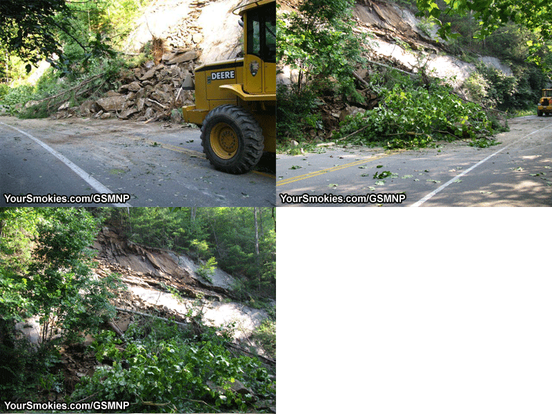
2nd Rock Slide in the Great Smoky Mountains national park will keep major road closed far longer

What in the Great Smoky Mountains national park as a simple clean up after a minor rock slide on Little River Road which connects Gatlinburg Tennessee with Cades Cove and Townsend Tennessee turned into a major project as a second landslide has left tons of debris precariously clinging to a cliff side which will take days to clean up.

About 30 truckloads of rock, lose soil and organic debris will need to be removed and carted away keep the stretch of Little Road between Elkmont and the Metcalf Bottoms Picnic area closed all weekend long and will probably not open now until at least Monday.

2nd Rock Slide in the Great Smoky Mountains national park will keep major road closed far longer

As seen in the animation above there is crumbly rock on the bluff that will fall on top the Little River roadway if left alone so the park service is using heavy equipment to remove any lose rock and material which will then have to be carted away.

No injurious, damage to vehicles, structures or park equipment has been reported at this time.

Rock Slide Closes Great Smoky Mountains National Parks Little River Road

A busy section of one the Great Smoky Mountains National Parks main thoroughfares will have a section closed for the next few hours between The Elkmont Campgrounds and the Metcalf Bottoms Picnic Area due to the cleanup in progress of a rock slide.

Visitors coming from Gatlinburg wishing to go to Cades Cove need to take the Gatlinburg Bypass or the Spur to get to Pigeon Forge.

From Pigeon Forge drivers must take 321 (Wears Valley Road) all the way to Townsend or if they choose enter the park through the back entrance on Wears Cove Road where they can take Little Rover Road all the way to the Townsend Wye.

Campers in the Elkmont campgrounds wanting to go to Cades Cove must go back towards Gatlinburg in order to take the detour around the rock slide on Little River Road.

Little River Road will be open for sure by the mid to late afternoon. We will announce and changes on the cleanup status of the rock slide in the Great Smoky Mountains national park.

Wednesday, August 12, 2009

Great Smoky Mountains National Park Presents Birds of Prey Program with Doris Mager

One of the most exciting moments a serious or fist time bird watchers has in the Great Smoky Mountains national park is when they get the chance to observe one of the elusive and beautiful birds of prey in the park.

This Saturday you will have the chance to join naturalist Doris Mager known as the "Eagle Lady" give a lecture on these amazing animals as well as the chance to see 4 of these animals up close and in person including an American Kestrel, a Screech Owl, and a Great Horned Owl.

Doris Mager is no spring chicken at 83 years of age but she still travels around the whole Eastern United States given lectures about her 35 years of experience helping hundreds of Raptors, more than 80 eagles and all the while housing up to 36 birds of prey at a time in her backyard.

North District Resource Education Supervisor of the Great Smoky Mountains national park promised that Doris Mager's 1 hour lecture starting at 10:30 am this Saturday August 15th at the Sugarlands Visitor Centers Theater will be a real treat for people who can attend.

After the lecture I would suggest that if you are looking to see a bird of prey on the wild you park your car midway on Hyatt Road in Cades Cove and walk around, climb Mount LeConte Via the Alum Cave Hiking Trail or check out the stretch of the AT between Charlie's Bunion and Snake Den Ridge Trail in Cosby.

Sunday, August 02, 2009

Can You Assist Scientists and Educators in the Great Smoky Mountains National Park?

Project Code Name: Stream Splashin' Science!
Project Objective: Collecting data to evaluate stream health and learning about the critters in the streams of the Great Smoky Mountains national park.
Project Destination: 2 Streams in the Great Smoky Mountains National Park
Project Date and Time: Tuesday August 4th, 10 am - 2 pm.
Project Predicted Weather: Mostly sunny with highs in upper 70's - low 80's with light winds.
Project Participants Requirements: For recent High School graduates to have a great time while learning about the Smokies
Required Equipment for Project Code Name Stream Splashin' Science: Long pants, hat, sun screen, closed toed shoes for hiking, sandals or water shoes to wade, drinking water, bag lunch, and your camera.
Participants Support Allowed: Bring your family to join in this exciting event!

If you wish to accept this mission please RSVP to Ranger Emily Guss at (865) 436-1292. You must give her the code phrase "healthy streams have plenty of salamanders" and you may join this very important Science Volunteer mission in the Great Smoky Mountains National Park.

If you wish to know of other Science Volunteer Opportunities missions in the Great Smoky Mountains national park that will be taking place this fall, ask Ranger Emily Guss to be placed on a mailing list for information about upcoming programs.

...end message

Saturday, August 01, 2009

Presumably Drowned Woman is Found Alive in the Great Smoky Mountains National Park

Miraculously the woman who jumped into the Great Smoky Mountains National Parks Little River which was rain swollen presumably to take her life and refused to be rescued by a park ranger, was spotted by a Park Volunteer at 10:45 am crossing the Little River at the Townsend Wye and was in the parking area at the Wye while scores of park rangers, fire department and rescue personnel spent a second day searching for her.

45 year old Carla S. Manzolini of Knoxville Tennessee

Though 45 year old Carla S. Manzolini of Knoxville Tennessee jumped off a rock when a concerned park ranger approached her due to her odd behavior into the raging river only a few hundred yards from the Metcalf Bottoms parking area where she left her vehicle, she ended up 7 miles downstream.

It is believed that she exited the flooded little River on the north shore at an elevation of 1,675 feet and hiked up to the Roundtop Trail which ranges in the area between 2,300 feet and 2,625 feet. From Little Roundtop she could have hiked east about 1-1/2 miles to Wears Cove Road or West as she did for about 6 miles.

Presumably Drowned Woman Found Alive in Great Smoky Mountains National Park

With so many park rangers and local rescue personnel it is easy to see the staggering cost of the rescue operation undertaken to save Carla Manzolini who was transported to Blount Memorial Hospital for evaluation.

Cades Cove Loop Road reopens, some other Great Smoky Mountains national park roads still closed

Little River Road in the Great Smoky Mountains national park between the Metcalf Bottoms Picnic area and the Townsend Wye remains closed today as park rangers attempt to find the body of a woman who drowned yesterday by jumping into the flooded Little River and refused to be rescued.

Cades Cove Loop Road which was closed yesterday due to flooding at numerous points is now open t all traffic, bicycles and pedestrians. Flooding and wind damage has kept 2 of the other major roads in Cades Cove closed: Rich Mountain Road and Parson Branch Road. No reopening date is anticipated yet.

In the south end of the Great Smoky Mountains national park in the Balsam Mountain area Heintooga Road is also closed due to storm damage with no reopen date.

Friday, July 31, 2009

Little River Road closed as Great Smoky Mountains national park searches for drowning victim

A section of Little River Road in the Great Smoky Mountains national park will be partially closed Saturday as the park service commences searching for the bodies of a woman who entered Little River and was swept away while refusing to allow a ranger rescue her.

While a park ranger was on patrol along the Little River he observed a white female approximately in her 30's sitting on a rock at the edge of the river. Since her behavior was unusual the ranger decided to check on her at which time she stood up and jumped into the raging river swollen and flooded from earlier today's heavy rains.

The Great Smoky Mountains national park ranger followed her as she was swept down the river and attempted to rescue her by throwing her a life line and float which she picked up and purposely tossed aside.

Little River Road was closed today from the Metcalf Bottoms Picnic area to the Townsend Wye as park rangers and first responders from Gatlinburg's Rescue Squad and Rural Metro Ambulance swarmed the area searching in vain for the women.

Rangers during daylight searched all along the riverbanks of the Little River which was running chocolate brown and loaded with debris. They also set up a vantage point by an area called the Sinks further down river from where the lady entered the water in an attempt to intercept the victim if she floated by.

Today's heavy rains also flooded Cades Cove along Sparks Lane, Hyatt Lane as some other stream crossing prompting the park service to Close Cades Cove Loop Road creating a traffic nightmare at the Townsend Wye.

While working traffic management at the Townsend Wye with 2 other volunteers in the park our park vehicle was struck by a pickup truck transporting kayaks. No injuries were sustained although the back door was taken off the park service's jeep Cherokee used by Volunteers in Cades Cove.

back door was taken off the park service's jeep Cherokee used by Volunteers in Cades Cove

Because Cades Cove Loop Road was closed tonight's very popular 3 mile night hike in Cades Cove with Ranger Mike which crosses a stream on Spark Lane that is to rough to cross today was canceled leading to many disappointed park visitors.

Cades Cove may reopen tomorrow if flood water subside enough.

Despite the extremely flooded conditions of Little River the kayakers pictured below were still out in force even past sunset. Expect the Great Smoky Mountains national park to have many kayakers and extreme tubers enjoy the flooded Little River tomorrow and throughout the weekend.

Despite the extremely flooded conditions of Little River kayakers were still out in force