Monday, May 19, 2008

Road closure and construction to last longer then scheduled in the Great Smoky Mountains national park.

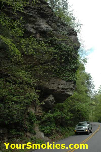
The work needed to stabilize Indian Head Cliff on Little River Road in the Tennessee side of the Great Smoky Mountains national park is taking longer than it was scheduled keeping 8 mile section of Little River Road between the Metcalf Picnic area and the Townsend Wye closed for an additional day.

When Little River Road reopens Tuesday evening the 20th it will be reduced to 1 lane while the work will have to continue for at least another week.

Hopefully Little River Road will be open completely by Memorial Day weekend as the Great Smoky Mountains National Park will be busy especially between Gatlinburg and Cades Cove.

Parson Branch Road in Cades Cove already shows wear and tear

Parson Branch Road in the back end of Cades Cove in the Great Smoky Mountains National Park was closed for years due to storm damage requiring the national park service to have a major overhaul done to the unimproved road which ends up on US 129.

While major work was done to this dirt and gravel road, there are already some serious pot holes and ruts that can do serious damage to a cars front end or make a car or motorcycle lose control if hit wrong. Most of the new damage to Parson Branch is in the upward grade and just after bridges and stream crossings.

Parson Branch Road is still a great way to see the Smokies up close without having to leave the car and allows you access to 2 trailheads of the Great Smoky Mountains national parks more quiet and secluded hiking trails - Gregory Bald Trail and the Hannah Mountain Trail.

Bikers - the motorcycle riding type in the Smoky Mountains - love Parson Branch road because it takes you out to the tail of the dragon - a road where high performance cars and motorcycle riders love the numerous hairpin turns and push their vehicles and driving skills to the edge.

Unfortunately many thrill seekers have been injured or lost their lives doing this and as a result traffic speed limits enforcement has developed a no tolerance for speeding and regularly cruise this stretch cracking down on anyone breaking the limit even if it is only a few miles over the posted speed.

By all means, take Parson Branch Road out of Cades Cove when you have the time - especially in Rhododendron season - but take it easy!

Friday, May 16, 2008

Great Smoky Mountains National Park Presents the 8th Annual Cosby in the Park Festival May 17th

Thanks to a partnership between the Great Smoky Mountains Association, the National Park Service and the Cocke County government this year the 8th annual Cosby in the Park festival held on Saturday, May 17, 2008 in the Cosby section of the Great Smoky Mountains national park should be fun and informative for visitors of all ages.

The Cosby in the Park festival is free to everyone and will include old time music, guided hikes, historical tales, storytelling and games for the kids and all sorts of activities and demonstrations for young and old alike.

Visitors can come to the national park from sunrise to sunset but the Cosby in the Park activities will take place from 10 am to 4 pm near the Cosby Campgrounds. You can bring your appetite too as a there will be a trailer from Angels Food Service selling traditional foods such as corn bread, pinto beans and tea. And for the kids there will be picnic style food such as hot dogs.

Beside the fun, games and food the 8th annual Cosby in the Park is meant to celebrate the cultural heritage of the Cosby area of the Great Smoky Mountains national park in Cocke County as well as demonstrating to visitors the recreational opportunities in the Cosby area.

If you are like me you will have a hard time choosing between the activities that will take place between the Cosby Picnic area and the outdoor amphitheater so I have a feeling I will be running back and forth between the 2 the whole day!

At the Cosby picnic pavilion there will be children's activates all day long which will include: Children's crafts and games, sack races and Crafter's Demonstrations: Bill Alexander, mountain berry baskets; Maria Holloway, quilting; Len Landrum, knife making and blacksmithing; Clayton Sharp, blacksmithing and mountain tools; Ellen Ogle, quilting; Connie Clabo, basket making; John and Sherry Holt, introduction to beekeeping; and Sherry Jennette and Sydney Fry, pine cone bird feeders.

Here is the schedule of events for the 8th annual Cosby in the Park festival broken down by location:

At the Cosby Amphitheater

  • 10 am - 11 am Old time music performed by the Lost Mill String Band
  • 11 am - 11:15 am Dedication of Cosby in the Park festival >
  • 11:15 am - 12 Noon Old time music performed by the Boogertown Gap Band
  • 12 Noon - 12:30 pm Hear Civil War Tales from Cosby by historian Duay O'Neil
  • 12:30 pm - 1 pm Storytelling by Faye Wooden
  • 1 pm - 1:45 pm Traditional bluegrass music performed by The Green Family Band
  • 1:45 pm - 2 pm Fiddle music by Robby Land
  • 2 pm - 3 pm Traditional old-time music performed by David McClary and Friends
  • 3 pm - 4 pm Old time music performed by the Curtis and Lynn Osteen

At the Cosby Picnic Pavilion

  • 1 pm Learn about the life of an extraordinary Cocke County mountain woman Ella V. Costner known as the Poet Laureate of the Smokies from Sheila Evans, Jordan Costner, and Claudia Konker
  • 1 pm Hug a Tree and Survive with Joey Holt
  • 2:30 pm Children's Storytelling with Faye Wooden

The guided hikes are:

  • At 11 am a 1 mile hike at the Cosby Nature Trail led by Morgan Briggs. The nature trail is by the amphitheater and that where the moderate hike will begin.
  • At 1:30 pm a 2 mile roundtrip hike starting at the Cosby picnic area pavilion to the Ella V Costner grave led by Judy McGaha, Shane McGaha and Pam Rodgers. There will be reading of poems during the moderate hike.

While I love hiking and generally hike 10 -15 miles day 7 days a week in the national park, I will sit this one out as I prefer the more challenging hikes Cosby offers. The guided hikes during the Cosby in the Park festival are great for beginners and those of you new to the Cosby area of the GSMNP.

Thursday, May 15, 2008

Goshin Prong and Backcountry Campsite #23 in the Great Smoky Mountains National Park is closed

The Great Smoky Mountains National Park has closed the Goshin Prong Hiking Trail in Elkmont Tennessee from the trailhead at the Little River junction and at the junction at the Appalachian Trail near Clingmans Dome.

The trail was closed to numerous blowdowns and is expected to take quite a while to reopen due to the extensive amount of work required to make the trail safe again for hikers.

Goshin Prong is one of my favorite trails to hike in the area with wonderful river and waterfall views and is normally not crowded.

The backcountry campsite #23 along the trail is also closed and will remain closed as long as the trail is closed.

Landslide in Great Smoky Mountains National Park closes hiking trail to Mount Le Conte

The Great Smoky Mountains national park has received some much needed seasonal rain which triggered a landslide on the Trillium Gap Hiking trail to Mount Le Conte from the Bushy Mountain trailhead in the Roaring Fork area near Gatlinburg Tennessee.

This popular hiking trail is not only popular with hikers wishing to climb to the top of Mount Le Conte because of its relatively lower angle of elevation; it also is the main thoroughfare for Llamas which bring supplies weekly up to the Mount Le Conte Lodge.

Landslide in Great Smoky Mountains National Park closing hiking trail.

We predicted considerable blow downs of tress and limbs in the park which turned out to come true so hikers and horseback riders in the Great Smoky Mountains national park can expect a large number of trails may have fresh downed trees requiring hikers to climb over or around them.

This week there have also been plenty of both small and large rocks that have fallen into the roadways. Drivers should use caution especially when driving in the early hours in the park before rocks have been cleaned off the road or at night when visibility is reduced.

It may take until sometime in June before the Trillium Gap hiking trail will reopen

Monday, May 12, 2008

Last of the hiking trails closed for prescribed burn in GSMNP Cades Cove/Abrams Creek section reopened

The April prescribed burn in the Cades Cove and Abrams Creek Section of the Great Smoky Mountains National park has kept hikers and campers from enjoying some of the GSMNP backcountry campsites and hiking trails for weeks.

Today the last hiking trail that remained closed from the burn - the Beard Cane Trail in the Abrams section has reopened as well as backcountry campsites #3 and #11 which have both been closed for weeks.

The prescribed burn in Cades Cove will help promote the growth of native yellow pine as well as reduce the ferocity of a wild fire in the area by reducing the potential fuel to feed the fire.

The picture above shows the immediate after effects of the prescribed burn on Cooper Road Trail near the Beard Cane junction.

Cades Cove seasonally closed to motorists Wednesday and Saturday Mornings

Bikers and hikers in the Great Smoky Mountains national park love this time of the year when the Cades Cove 11 mile Scenic Motor trail also know as the Cades Cove Loop Road is closed to motor vehicles until 10:00 am on Wednesdays and Saturdays.

Bicyclists in Cades Cove increase number during the warmer months and it is a please to ride you bike or hike without worrying about traffic so the national park service keeps traffic of the road to the great pleasure of hikers and bikers.

Early mornings are magical in the Cades Cove section of the Great Smoky Mountains national park near Townsend Tennessee. Fog may settle in the valley slowly revealing the mountains as the sun comes up over the mountains. Deer, black bear and wild turkey roam in the fields of Cades Cove and along tree lines giving visitors a chance to see and hear the native wildlife.

Cades Cove seasonally closed to motorists Wednesday and Saturday Mornings

This time of the year the birds are singing up a racket and blue and yellow butterflies will be fluttering in the wind. Beside the birds the other predominate sound of the Cades Cove valley before the traffic begins is the buzzing of bees flying from wildflower to wildflower which carpet the cove and fill the woods.

Hikers who start early enough just at the crack of dawn can make it to the back end of the Cades Cove Loop if not finish the 11 miles before the see or hear a single car.

This is my favorite time of the year in my favorite place in the Smokies!

High winds in the Smokies expected today can cause problems for hikers

The past few days storms and high winds have caused trees and branches to fall in the Great Smoky Mountains National Park hiking trails and weakened others which may fall during today’s predicted high winds.

Hikers in the Smokies should keep their eyes open if hiking especially during the high winds by looking to see if there are snags above the trail and remain cautious or avoiding walking under or near snags, dead or damaged trees.

Wind gust speeds are expected to hit 30 mph or more on the Tennessee side and up to 40 mph on the North Carolina side of the Great Smoky Mountains National Park.

Saturday, May 10, 2008

Great Smoky mounatins National Park East - West road Little River Road reopens

Little River Road the main east west road in the Great Smoky Mountains national park reopened today in time for Mothers Day weekend.

Downed branches from last night storm have been cleared off of all of the major roads and all of the trails we have checked show only minimal damage.

As of Monday a section of Little River Road from the Metcalf picnic grounds to the Townsend Wye will be closed completely for the geologic repair to Indian Head Cliff.

Click here for further information about the Little River Road Closure and Indian Head Cliff repair.

Little River Road Closure in Great Smoky Mountains National Park

Westbound drivers in the Great Smoky Mountains national park will have to exit Little River Road at Metcalf Bottoms Picnic area and go west via 321.

Plenty of tress branches and leaves are down so drivers must remain cautious.

Power outages and trees down in Sevier County Tennessee

Last night severe thunderstorms and hail storms pounded Sevier County Tennessee dumping plenty of rain and knocking down trees.

Currently the Your Smokies office in Sevierville just had power restored only minutes ago as we ready ourselves to survey damage in the national park and surrounding areas.

Drivers are asked to be very cautious as we expect trees, limbs and branches to be in roadway and fallen wet leaves may also present a hazard to drivers.

Hikers should also expect to possibility of newly downed trees to create potential hazards on hiking trails and we suggest allowing a day or 2 before taking a horse out in the park so that the trails can be surveyed for damage.

Friday, May 09, 2008

Hiking Trails in the Great Smoky Mountains National Parks have reopened

The remaining hiking trails in the Great Smoky Mountains National park other than Beard Cane Trail in Abrams Creek that were closed due to Aprils prescribed burn in Cades Cove have all reopened.

These trails are all quiet right now and offer hikers a chance to see what the prescribed burn has done along with plenty of peace and solitude.

Plenty of wild flowers and flowering bushes and trees can be seen on these trails as well.

The 2 hiking trails that are closed due to bear activity: Turkey Pen and School House Gap.

Thursday, May 08, 2008

Fires on Shields Mountains are out in Sevierville

Residents and homeowners can breath a sigh of relief for now as both wildfires on Shields Mountains are out.

While fire officials still have not determined the cause of either fire, they are confident that both wildfires will now have to be continued to be monitored as they smolder.

Rain was expected today but so far Shields Mountain remains dry. A good soaking rain would help put out some of the remaining hot spots that are still left.

Fire officials stressed the fact that keeping at least a 30 foot defendable area around residences would help keep property damage to a minimum and clearing up bush and debris would also help keep the danger of wildfires reduced.

More information on fire safety as well as what you can do to reduce the danger to you business or residence can be found at the Firewise Web Site.

Shields Mountain wild fire burns more than 40 acres

More than 40 acres is already effected by the Wildfire on Shields Mountain as the winds are now kicking up.

Firefighters in sector 2 are now using hand tools descending down the mountain to make a scratch line to contain the the fire into a hollow.


It looks at this point as though everything will be under control shortly.

Wildfire on tower road still burning on Sheilds Mountain Sevierville

The sound of many fire engine sirens is echoing through Shields Mountain as the new wildfire on tower road belches even more smoke into the air.

While a few acres have already burned Pigeon Forge firefighters feel as though the brush is still green enough to keep the fire from getting out of control unless some of the larger trees flare up.


Tennessee forestry fire fighters or working the line near the Verizon Cellphone tower and power lines which as of yet are not in danger.

1 fire contained on Sheilds Mountain and another on started

Fire fighters from Sevierville, Pigeon Forge, English Mountain, Sevier County, Kodiak, Walden's Creek, Pitman Center and Gatlinburg worked all night and were able to contain a brush fire on Shields Mountain in Sevierville.

Fire crews left the still smoldering brush to respond to another fire on Shields Mountain on Tower Road.

Wednesday, May 07, 2008

Wildfire burning on Shields Mountain in Severville Tennessee

A small wildfire forced the evacuation of some residents of cabins by the Pigeon Forge fire department.


When we first arrived on the scene smoke was still filling the valley but flames are no longer visible. Minutes later brush flared up and fire fighters tackled the flames from the deck of 2 cabins and use the help of a wetting agent spraying down trees next to the cabins to keep them from catching on fire.


Since there is no city water or working fire hydrants up on this mountain fire crews are pulling water from homeowners holding tanks to fight the fire.

Monday, May 05, 2008

Black Bears are active in the Great Smoky Mountains national park prompting hiking trail closure.

Springtime in the Great Smoky Mountains national park means that the resident black bear have become more active and you can find mother black bears with their cubs which can be potentially dangerous of mother bear feels that you are a threat to her cubs.

During the winter months, black bear in the Great Smoky Mountains national park become far less active but since last months warming temperatures if you look careful you will find plant of bear through put the park.

As a result of a mother bear being protective of her young some popular hiking trails between on the north side of Laurel Road between the Townsend Wye and Cades Cove are now closed due to aggressive black bear activity.

The Schoolhouse Gap Trail shared by hikers and horses alike as well as the Turkey Pen Ridge trail are now closed and are not expected to reopen for at least a few weeks.

Bears are active in the Great Smoky Mountains national park prompting hiking trail closure.

Hiking trails, backcountry campsites, Cades Cove still closed from Aprils prescribed fire

Some hiking trails and backcountry campgrounds in the Great Smoky Mountains National park still remain closed more than a week after the controlled fire in Cades Cove.

Fire was used by the national park service to help promote the growth of yellow pine and by burning some of the dead brush now, reduce the risk of a wildfire by limiting the fuel the dead brush would provide.


Cooper Road Trail

Normally trails and backcountry campgrounds would reopen after a controlled burn with a few days after the park service confirms that all hot spots on the hiking trail that can rekindle a fire have been extinguished and that there is no danger to hikers from limbs and trees that may fall.

The following trails are still closed in the North West corner of Cades Cove:

  • The Cooper Road hiking trail at the Wet Bottom Trail junction starting 0.2 miles from Cades Cove loop road all 5.3 miles to the to the Beard Cane Trail junction.
  • The Beard Cane Trail for the entire length of 4.2 miles from Ace Gap Trail to the Cooper Road Hiking trail

The following backcountry campgrounds remain closed in the North West corner of Cades Cove:

  • Backcountry camp site #3 on the North end of Beard Cane Trail
  • Backcountry camp site #11 on the South end of Beard Cane Trail

Sunday, May 04, 2008

Great Smoky Mountains National park cliff repair causes road closures and detours.

Little River Road on the Tennessee side of the Great Smoky Mountains national park connecting Gatlinburg Tennessee with Elkmont, Metcalf Bottoms, and Townsend Wye will be reduced to shortly to 1 lane and then have a section closed while rehabilitate construction will take place to Indian Head Rock cliff.

This construction and closure will be effecting through drivers attempting to traverse the park to get to Cades Cove and the Tremont sections of the national park whose best option would be to take 321 and avoid the whole mess.

The Indian Head Rock Cliff which is located between Metcalf Bottoms and the Townsend Wye was damaged during the heavy storm in October of 2006 that ripped through the park destroying much in its path.

Along with blowing down hundreds of large trees this storm damaged the Indian Head Rock Cliff rock face triggering a landslide which dumped debris and large boulders onto the Little River Road.

Indian Head Cliff on Little River Road

On April 3, 2008 the Great Smoky Mountains national park awarded a $386,360 contract to Rembco Geotechnical Contractors of Knoxville Tennessee to stabilize the rock face by using polyurethane resin to fill in the large cracks along with using rock dowels based upon recommendations by the Federal Highway Administration geological engineers.

As a result of the rehabilitation of the Indian Head Rock Cliff, drivers will find that the Little River Road lane and complete closures from May 5th to May 19th with a welcome break on Mothers Day weekend May 9-11 when no construction work will be conducted and Little River Road will be fully operational.

Little River Road construction map in the Great Smoky Mountains National Park

The following schedule is subject top change if the weather or if geologic rehabilitation does not go as planned:

  • May 5th through May 8th. Traffic on effected area (see map) will be reduced to 1 lane controlled by flaggers. Drivers can expect delays.

  • May 9th through May 11th. No construction. Both lanes on Little River Road will be open and there will be no delays.

  • May 12th through May 19th. Both lanes of effected area (see map) will be closed to all traffic.

    Eastbound Detour
    Traffic headed eastbound from Cades Cove or Tremont must exit to the Townsend Wye and Detour via 321. Passenger cars and vans may reenter park at Wear Cove Entrance in order to get back onto eastbound Little River Road at Metcalf Bottoms to continue eastward. Larger Vehicles must reenter park Via the Spur.

    West Bound Detour
    Divers of passenger cars and vans coming from Gatlinburg or Elmont wishing to go west to Cades Cove or Tremont section of the Great Smoky Mountains national park must exit Little River Road at Metcalf Bottoms Picnic area and exit park at the Wears Cove entrance and reenter the park at the Townsend Wye. Larger vehicles must exit park at the spur and take 441 and then 321 to the Townsend Wye.

    During May 12th through May 19th Both pedestrians and cyclists will be allowed to go from Metcalf bottoms to the sinks. Little River Road from the Townsend Wye east is closed to all pedestrians and cyclists.